

|
|
| Mesoscale Discussion 651 | |
 | |
   Mesoscale Discussion 0651
   NWS Storm Prediction Center Norman OK
   0518 AM CDT Wed May 06 2026

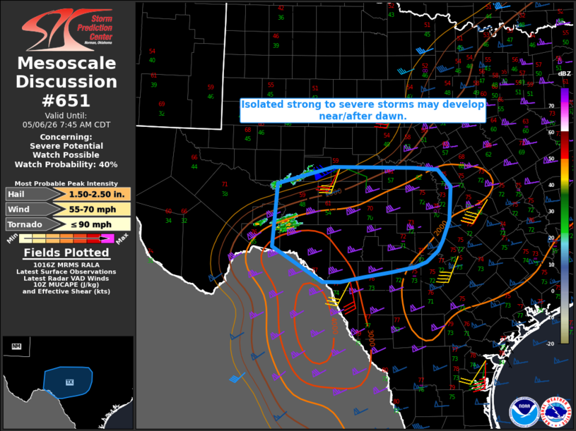
   Areas affected...Parts of the TX Hill Country and Edwards Plateau

   Concerning...Severe potential...Watch possible

   Valid 061018Z - 061245Z

   Probability of Watch Issuance...40 percent

   SUMMARY...Isolated strong to severe storms may develop near or after
   dawn.

   DISCUSSION...GPS PW values near Del Rio have substantially increased
   from near 1 inch at 00 UTC to above 1.5 inches as of 10 UTC, with
   surface dewpoints increasing through the low 70s F. A storm has
   recently developed northwest of Del Rio across eastern Terrell
   County, and this increase in deeper low-level moisture beneath
   relatively steep midlevel lapse rates may yield additional storm
   development near a weak surface front draped across the TX Hill
   Country vicinity. MUCAPE of 2000 J/kg, strong (60+ kt) deep-layer
   shear, and elongated hodographs are conditionally supportive of
   supercells capable of producing large to very large hail, if deep
   convection can mature within this regime.

   In the absence of substantial large-scale ascent, storm coverage
   through the morning is uncertain. However, given the favorable
   environment, watch issuance is possible if short-term trends support
   development of persistent intense storms.

   ..Dean/Mosier.. 05/06/2026

   ...Please see www.spc.noaa.gov for graphic product...

   ATTN...WFO...FWD...EWX...SJT...MAF...

   LAT...LON   29880192 31040181 31340064 31339891 31299841 30979815
               30369818 29989833 29809843 29609867 29519893 29429940
               29329999 29240049 29240086 29880192

   MOST PROBABLE PEAK TORNADO INTENSITY...UP TO 90 MPH
   MOST PROBABLE PEAK WIND GUST...55-70 MPH
   MOST PROBABLE PEAK HAIL SIZE...1.50-2.50 IN
| |
| Top/All Mesoscale Discussions/Forecast Products/Home | |