|
|
| Mesoscale Discussion 648 | |
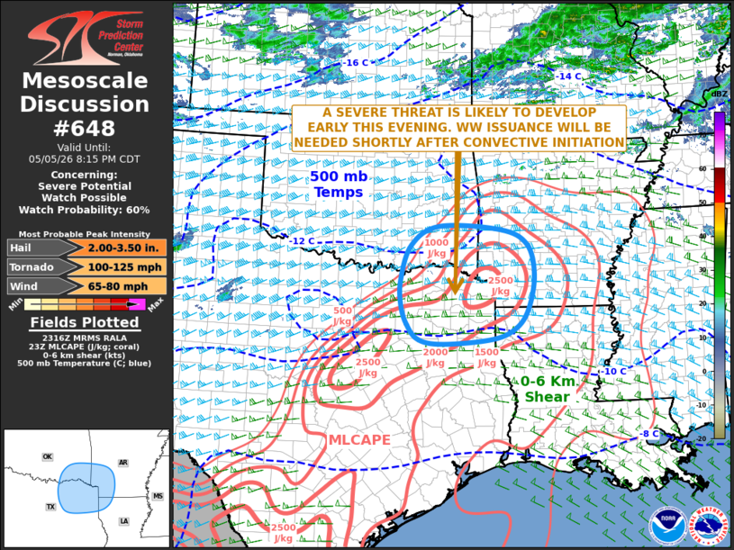 | |
   Mesoscale Discussion 0648
   NWS Storm Prediction Center Norman OK
   0619 PM CDT Tue May 05 2026

   Areas affected...Northeast Texas...Far Northwest Louisiana...Far
   Southeast Oklahoma...Southwest Arkansas

   Concerning...Severe potential...Watch possible

   Valid 052319Z - 060115Z

   Probability of Watch Issuance...60 percent

   SUMMARY...A severe threat is likely to develop early this evening
   across parts of northeast Texas, far southeast Oklahoma and
   southwest Arkansas. Large hail, severe wind gusts, and an isolated
   tornado threat will be possible. Weather watch will likely be needed
   once convective initiation takes place.

   DISCUSSION...Surface analysis shows a cold front from southeast
   Oklahoma extending southwestward to near the Dallas/Fort Worth Metro
   and into north-central Texas. Along and ahead of the front, a field
   of cumulus is evident on visible satellite imagery. Low-level
   convergence is likely maximized near Fort Worth, where a boundary
   from the southeast recently merged with the cold front. Short-term
   model forecasts suggest that cells will initiate near the front
   early this evening from the Dallas/Fort Worth Metro northeastward
   into northeast Texas. Ahead of the front, moderate instability is
   analyzed with the RAP showing MLCAPE in the 2000 to 3000 J/kg range.
   In addition, the WSR-88D VWP at Fort Worth has 0-6 km shear near 70
   knots. The RAP has 700-500 mb lapse rates in the 7.5 to 8 C/km
   range. This should support supercells with large hail, and
   hailstones greater than 2 inches in diameter will be possible. The
   storms may also be associated with severe wind gusts and an isolated
   tornado threat.

   ..Broyles/Hart.. 05/05/2026

   ...Please see www.spc.noaa.gov for graphic product...

   ATTN...WFO...LZK...SHV...TSA...FWD...OUN...

   LAT...LON   34649389 34349323 33699305 32999320 32579352 32339410
               32239532 32329595 32659625 33069639 33599641 34329614
               34719544 34649389

   MOST PROBABLE PEAK TORNADO INTENSITY...100-125 MPH
   MOST PROBABLE PEAK WIND GUST...65-80 MPH
   MOST PROBABLE PEAK HAIL SIZE...2.00-3.50 IN
| |
| Top/All Mesoscale Discussions/Forecast Products/Home | |