|
|
| Mesoscale Discussion 593 | |
| Next MD > | |
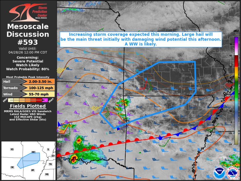 | |
   Mesoscale Discussion 0593
   NWS Storm Prediction Center Norman OK
   1001 AM CDT Tue Apr 28 2026

   Areas affected...northeast Oklahoma into southern Missouri and
   northern Arkansas

   Concerning...Severe potential...Watch likely

   Valid 281501Z - 281700Z

   Probability of Watch Issuance...80 percent

   SUMMARY...Strong to severe thunderstorms are expected to increase in
   areal coverage across the discussion area this morning. Large hail
   will be the primary hazard initially, with damaging wind potential
   increasing this afternoon. A Severe Thunderstorm watch will likely
   be required to address this severe weather threat.

   DISCUSSION...Recent radar trends indicate thunderstorms gradually
   increasing in coverage across portions of eastern OK, driven largely
   by a low-level warm advection regime occurring to the north of a
   surface boundary stalled across southeast OK into central AR. RAP
   proximity soundings suggest the developing storms are rooted in a
   moist layer centered around 850 mb, with steep mid-level lapse rates
   contributing to MUCAPE of 1500-2000 J/kg.

   Water vapor imagery shows a vigorous short-wave trough moving into
   western KS this morning with an area of downstream, implied forcing
   for ascent progressively overspreading the discussion area over the
   next several hours. That combined with the available reservoir of
   moderate, elevated instability, and relatively strong cloud-bearing
   shear will support the potential for elevated supercells capable of
   large hail initially. Some cloud breaks (evident in visible
   satellite) may allow for a subset of the elevated storms to become
   surface-based by afternoon, at which point, a damaging wind threat
   would increase.

   ..Mead/Guyer.. 04/28/2026

   ...Please see www.spc.noaa.gov for graphic product...

   ATTN...WFO...PAH...LSX...LZK...SGF...TSA...

   LAT...LON   35769576 36959488 37869282 37869097 36649096 36149149
               35549395 35169505 35769576

   MOST PROBABLE PEAK TORNADO INTENSITY...100-125 MPH
   MOST PROBABLE PEAK WIND GUST...55-70 MPH
   MOST PROBABLE PEAK HAIL SIZE...2.00-3.50 IN
| |
| Top/All Mesoscale Discussions/Forecast Products/Home | |