|
|
| Mesoscale Discussion 554 | |
| Next MD > | |
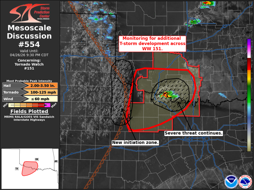 | |
Mesoscale Discussion 0554 NWS Storm Prediction Center Norman OK 0724 PM CDT Sun Apr 26 2026 Areas affected...Southern Oklahoma and northwest Texas Concerning...Tornado Watch 151... Valid 270024Z - 270230Z The severe weather threat for Tornado Watch 151 continues. SUMMARY...The potential for additional severe thunderstorms continues across portions of southern Oklahoma and northwest Texas. If storms develop, they will pose a threat for very large hail, tornadoes, and severe gusts. DISCUSSION...Over the past hour, a pair of left/right-split supercells has produced several very large hail reports upwards of 3 inches. Although the left-split has recently weakened, the right moving supercell residing along the Red River has recently shown an uptick in intensity after a temporary weakening. The near-storm thermodynamic environment remains favorable for storm maintenance, and the kinematic environment is forecast to improve over the next few hours as a nocturnal jet gradually strengthens. As such, the greatest near-term severe risk will continue to reside immediately downstream of the ongoing supercell where very large hail will remain the primary hazard for the short-term (though some increase in tornado potential is anticipated later this evening coincident with the strengthening nocturnal jet). Further to the west, clustering cumulus on the immediate dry side of the dryline continues to gradually deepen per GOES IR imagery. Focused low-level convergence along a bulge in the dryline along with increasing synoptic ascent (associated with an approaching upper wave to the west) may support deeper convective towers over the next couple of hours. This may present an opportunity for additional thunderstorm development along the dryline that could pose a threat for all hazards across western portions of WW 151. While confidence in this scenario is somewhat low given the approaching onset of nocturnal cooling/stabilization, latest high-res guidance suggests that additional robust convection is plausible within the next 1-2 hours. ..Moore.. 04/27/2026 ...Please see www.spc.noaa.gov for graphic product... ATTN...WFO...FWD...OUN...SJT... LAT...LON 33259958 33579953 34599932 34829922 34889891 34829734 34619712 34259706 33939716 33639744 33369792 33189833 33059876 33019904 32999928 33049949 33259958 MOST PROBABLE PEAK TORNADO INTENSITY...100-125 MPH MOST PROBABLE PEAK WIND GUST...UP TO 60 MPH MOST PROBABLE PEAK HAIL SIZE...2.00-3.50 IN | |
| Top/All Mesoscale Discussions/Forecast Products/Home | |