|
|
| Mesoscale Discussion 551 | |
| Next MD > | |
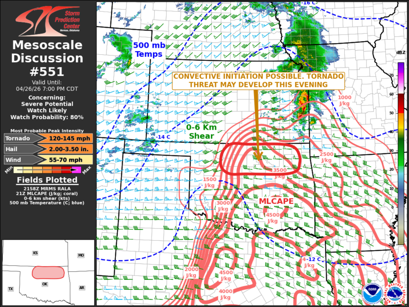 | |
   Mesoscale Discussion 0551
   NWS Storm Prediction Center Norman OK
   0500 PM CDT Sun Apr 26 2026

   Areas affected...North-central and Northeast Oklahoma

   Concerning...Severe potential...Watch likely

   Valid 262200Z - 270000Z

   Probability of Watch Issuance...80 percent

   SUMMARY...Convective initiation will be possible this evening across
   north-central Oklahoma. If this takes place, a tornado threat will
   become likely. Tornado watch issuance is anticipated over the next
   hour.

   DISCUSSION...Latest surface analysis shows a very moist airmass in
   place over much of Oklahoma with surface dewpoints in the upper 60s
   and lower 70s F. A surface trough is oriented from southwest to
   northeast across north-central Oklahoma, where low-level convergence
   is maximized. Along this zone, satellite imagery shows an agitated
   field of cumulus along the I-35 corridor in northern Oklahoma. To
   the east of the trough, the air is very unstable with the RAP
   showing MLCAPE in the 3000 to 4000 J/kg range. In addition, a strong
   wind field is in place with 0-6 km shear estimated by the RAP to be
   in the 35 to 45 knot range. While large-scale ascent does not look
   to be strong near the surface trough, low-level convergence could be
   enough to initiate convection at some point this evening. If this
   where to occur, then rapid supercell development would be expected,
   and a tornado threat would become likely. Large hail and severe wind
   gusts would also be likely.

   ..Broyles/Leitman.. 04/26/2026

   ...Please see www.spc.noaa.gov for graphic product...

   ATTN...WFO...TSA...OUN...

   LAT...LON   36989591 36849528 36529508 36279509 36009522 35899582
               35909748 35899817 36069853 36329864 36719855 36999816
               36989735 36989591

   MOST PROBABLE PEAK TORNADO INTENSITY...120-145 MPH
   MOST PROBABLE PEAK WIND GUST...55-70 MPH
   MOST PROBABLE PEAK HAIL SIZE...2.00-3.50 IN
| |
| Top/All Mesoscale Discussions/Forecast Products/Home | |