
|
|
| Mesoscale Discussion 484 | |
| Next MD > | |
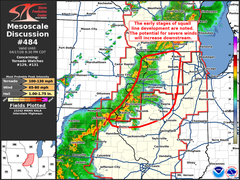 | |
Mesoscale Discussion 0484 NWS Storm Prediction Center Norman OK 0625 PM CDT Fri Apr 17 2026 Areas affected...Northwest Illinois Concerning...Tornado Watch 129...131... Valid 172325Z - 180130Z The severe weather threat for Tornado Watch 129, 131 continues. SUMMARY...A transition to a predominantly linear storm mode is likely underway and will result in an uptick in severe wind potential as well as embedded mesovorticies downstream across central/northern Illinois. DISCUSSION...Imagery out of KDVN shows signs of cold pool consolidation and expansion as convection continues to cluster and grow upscale, likely indicating the transition from semi-discrete cells and clusters to a more consolidated linear storm mode. Over the next couple of hours one or more organized lines should emerge across central to north-central IL. This will be accompanied by an increase in severe wind potential as well as the possibility of embedded mesovorticies, especially given steadily strengthening low-level flow/improving wind shear noted in downstream VWPs. Localized corridors of enhanced wind, and perhaps tornado, potential are expected where line-preceding convection (noted in west-central IL) eventually intersect the developing line, and could result in localized surges accompanied by swaths of stronger (potentially significant) winds. ..Moore.. 04/17/2026 ...Please see www.spc.noaa.gov for graphic product... ATTN...WFO...LOT...ILX...MKX...LSX...DVN... LAT...LON 40419175 40709132 41209087 41579060 41979046 42249042 42359025 42528902 42488881 42368866 42168867 41868873 41508878 41168882 40778894 40478917 40268950 40099007 39999048 39989091 39989136 40039167 40169180 40259182 40419175 MOST PROBABLE PEAK TORNADO INTENSITY...100-130 MPH MOST PROBABLE PEAK WIND GUST...65-80 MPH MOST PROBABLE PEAK HAIL SIZE...1.00-1.75 IN | |
| Top/All Mesoscale Discussions/Forecast Products/Home | |