|
|
| Mesoscale Discussion 459 | |
| Next MD > | |
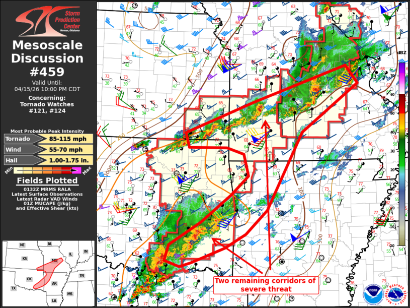 | |
Mesoscale Discussion 0459 NWS Storm Prediction Center Norman OK 0834 PM CDT Wed Apr 15 2026 Areas affected...Eastern Oklahoma to southern Missouri Concerning...Tornado Watch 121...124... Valid 160134Z - 160300Z The severe weather threat for Tornado Watch 121, 124 continues. SUMMARY...Two corridors of severe threat are expected to persist until 03-05z from the Kansas/Oklahoma border into southern Missouri, and from southeast Oklahoma into west central/northwest Arkansas. WW 121 will be extended until 05z. DISCUSSION...Convection has evolved into two primary corridors along composite outflow boundaries: 1) from the KS/OK border eastward into MO, and 2) from southeast OK toward west central AR. The northern corridor still has sufficient buoyancy to maintain a wind/hail and isolated tornado threat, based on the 00z SGF sounding. The bowing segment in south central MO will approach areas west of Saint Louis, but it is unclear if the storms will maintain intensity past the MS River. The southern corridor of storms will likewise persist for another couple of hours in an environment with moderate buoyancy and sufficient deep-layer vertical shear to maintain a severe threat. The large mass of convection and an expansive cold pool suggest that the storms will persist, but buoyancy decreases gradually with eastward extent. A local extension in time of WW 121 until 05z would likely cover the remaining threat across southeast OK and southwest MO. ..Thompson.. 04/16/2026 ...Please see www.spc.noaa.gov for graphic product... ATTN...WFO...LSX...LZK...SGF...SHV...TSA...ICT...OUN... LAT...LON 34749409 34419470 34059567 33969600 34099644 34479632 35029540 35689453 36139402 36669417 36819467 36819579 37159590 37909388 38769108 38339074 37189243 35319347 34749409 MOST PROBABLE PEAK TORNADO INTENSITY...85-115 MPH MOST PROBABLE PEAK WIND GUST...55-70 MPH MOST PROBABLE PEAK HAIL SIZE...1.00-1.75 IN | |
| Top/All Mesoscale Discussions/Forecast Products/Home | |