|
|
| Mesoscale Discussion 453 | |
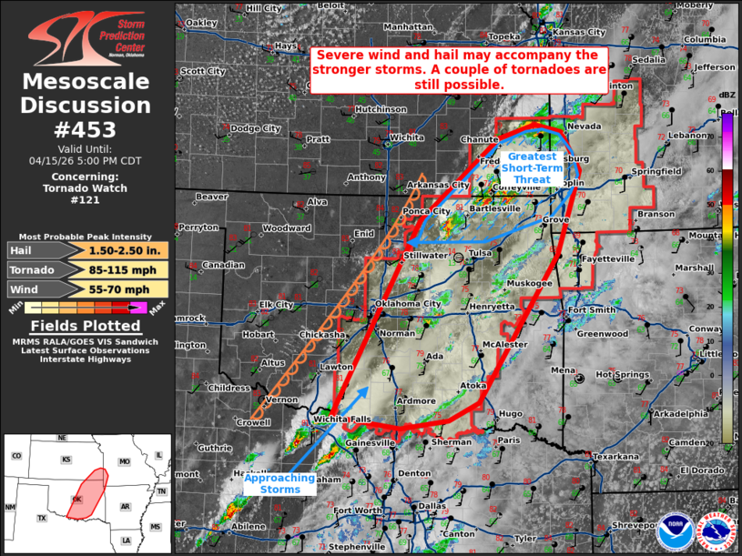 | |
Mesoscale Discussion 0453 NWS Storm Prediction Center Norman OK 0355 PM CDT Wed Apr 15 2026 Areas affected...portions of central and eastern Oklahoma into southeastern Kansas and far southwestern Missouri Concerning...Tornado Watch 121... Valid 152055Z - 152200Z The severe weather threat for Tornado Watch 121 continues. SUMMARY...A severe wind and hail threat should persist for several more hours, and a couple tornadoes remain possible. DISCUSSION...Multiple supercell thunderstorms have developed over the past couple of hours over portions of northeastern OK into southeastern KS, where severe hail has been reported. Additional storms have recently matured over northwestern TX and are approaching the Red River. All of these storms are traversing the warm sector immediately ahead of the dryline, where 2500+ J/kg MLCAPE and over 60 kts of effective bulk shear resides. As such, supercells should persist from the Red River toward the Ozarks for several more hours, accompanied by a severe wind/hail threat. Regional VADs show modest speed shear contributing to elongated hodographs, but with little low-level curvature, so tornado potential appears modest. Still, a couple of tornadoes cannot be ruled out if supercells can persist in a discrete fashion. The greatest short-term severe threat exists with ongoing storms in northeastern OK, where vertical wind shear is locally stronger. ..Squitieri.. 04/15/2026 ...Please see www.spc.noaa.gov for graphic product... ATTN...WFO...SGF...TSA...ICT...FWD...OUN... LAT...LON 34049819 36669677 37769546 37949487 37849443 37329413 36219451 34249581 33999630 33899707 34049819 MOST PROBABLE PEAK TORNADO INTENSITY...85-115 MPH MOST PROBABLE PEAK WIND GUST...55-70 MPH MOST PROBABLE PEAK HAIL SIZE...1.50-2.50 IN | |
| Top/All Mesoscale Discussions/Forecast Products/Home | |