|
|
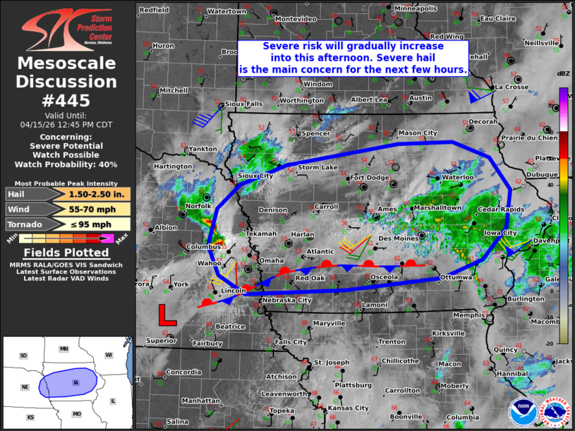
| Mesoscale Discussion 445 | |
 | |
   Mesoscale Discussion 0445
   NWS Storm Prediction Center Norman OK
   1022 AM CDT Wed Apr 15 2026

   Areas affected...Eastern Nebraska into much of Iowa

   Concerning...Severe potential...Watch possible

   Valid 151522Z - 151745Z

   Probability of Watch Issuance...40 percent

   SUMMARY...The severe risk will gradually increase and spread
   eastward into this afternoon. A few instances of severe hail is the
   main concern for the next few hours. While timing is uncertain, a
   watch may eventually be needed for parts of the area.

   DISCUSSION...Water-vapor imagery indicates a midlevel trough moving
   eastward across the central Plains, preceded by around 50 kt of
   southwesterly midlevel flow (per regional VWP data). An accompanying
   surface low, currently analyzed over southeast NE, will track
   eastward along a composite outflow/stationary front draped across
   southern IA into this afternoon. Isolated elevated thunderstorms are
   already evolving to the northeast of the surface low and to the
   north of the boundary in eastern NE, which will pose a risk of
   isolated severe hail in the near term. This activity will generally
   spread/develop eastward along/north of the surface boundary in
   tandem with the surface low and deep-layer ascent accompanying the
   midlevel trough into this afternoon. Despite the expected elevated
   nature of these storms for the next several hours,
   elongated/straight hodographs (40-50 kt of effective shear) and
   steep midlevel lapse rates/modest buoyancy atop the boundary layer
   will support transient elevated supercell structures capable of
   producing severe hail.

   With time, the low-level mass response accompanying the midlevel
   trough and surface low will draw lower/middle 60s dewpoints
   northward into central IA in the wake of ongoing convection.
   Depending on the degree of diurnal heating in cloud breaks, this may
   support a transition to surface-based storms into the afternoon,
   with an associated risk for damaging wind gusts and large hail with
   organized clusters and supercells. It is unclear if the
   ongoing/morning and early-afternoon elevated storms will warrant a
   watch, though current thinking is that a watch may eventually be
   needed for parts of the area.

   ..Weinman/Gleason.. 04/15/2026

   ...Please see www.spc.noaa.gov for graphic product...

   ATTN...WFO...DVN...ARX...DMX...FSD...OAX...

   LAT...LON   40829616 41109669 41539692 42079675 42439631 42739541
               43059318 43079208 42849135 42369096 41799105 41349153
               41089232 40909421 40829616

   MOST PROBABLE PEAK TORNADO INTENSITY...UP TO 95 MPH
   MOST PROBABLE PEAK WIND GUST...55-70 MPH
   MOST PROBABLE PEAK HAIL SIZE...1.50-2.50 IN
| |
| Top/All Mesoscale Discussions/Forecast Products/Home | |