|
|
| Mesoscale Discussion 419 | |
| Next MD > | |
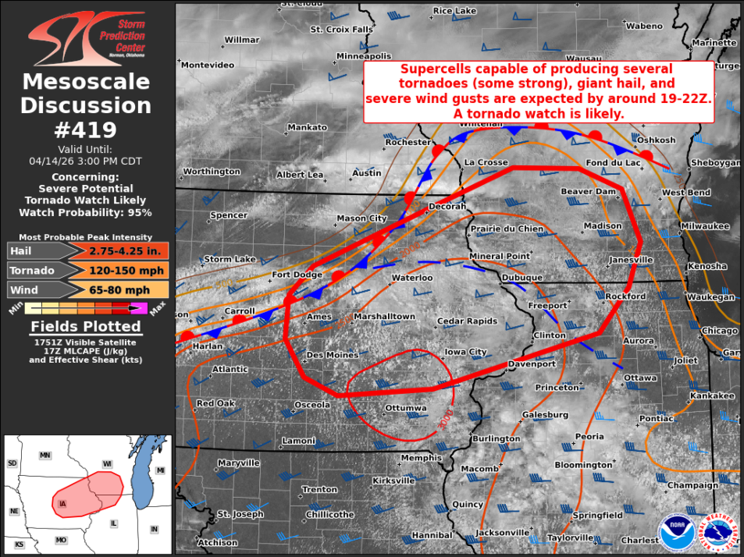 | |
   Mesoscale Discussion 0419
   NWS Storm Prediction Center Norman OK
   1256 PM CDT Tue Apr 14 2026

   Areas affected...Parts of central/eastern IA...southern WI...and
   northern IL

   Concerning...Severe potential...Tornado Watch likely

   Valid 141756Z - 142000Z

   Probability of Watch Issuance...95 percent

   SUMMARY...The risk of supercells capable of producing several
   tornadoes (some strong to intense), giant hail, and severe wind
   gusts will increase by around 19-22Z. A tornado watch is likely
   within the next couple hours.

   DISCUSSION...The latest surface analysis depicts a quasi-stationary
   boundary extending from central/northern IA into southern/central
   WI, with an additional composite outflow boundary farther south from
   northeast IA into northern IL. Over the next few hours, continued
   diurnal heating of a moist air mass (upper 60s dewpoints) should
   erode remaining inhibition at the base a substantial EML, resulting
   in the development of strong surface-based buoyancy (upwards of
   3000-3500 J/kg MLCAPE). As this occurs, initial thunderstorm
   development is expected across parts of central/eastern IA near the
   intersecting boundaries by around 19-22Z -- aided by a subtle
   frontal wave tracking eastward along the quasi-stationary boundary.

   The strongly unstable air mass coupled with 40-50 kt of effective
   shear will favor rapid thunderstorm organization/intensification
   into semi-discrete supercells and organized clusters. Initially,
   very large to giant hail (2-3+ inches in diameter) and severe wind
   gusts will be the main concern with potentially splitting supercells
   -- given a mostly straight hodograph. However, a south-southwesterly
   low-level jet will strengthen across the area later this afternoon
   into the evening and likely favor a transition to dominant
   right-moving supercells with a quickly increasing tornado risk. The
   strong buoyancy and 200-300+ m2/s2 effective SRH will support strong
   to intense tornadoes with any longer-lived supercells, along with a
   continued risk of giant hail and severe gusts. Eventually,
   thunderstorms may have a tendency of growing upscale into clusters
   with eastward extent, which will yield an increasing risk of
   damaging wind swaths.

   A tornado watch will be issued within the next couple hours.

   ..Weinman/Gleason.. 04/14/2026

   ...Please see www.spc.noaa.gov for graphic product...

   ATTN...WFO...LOT...MKX...DVN...ARX...DMX...

   LAT...LON   41219309 41419361 41849390 42349386 42679350 43349177
               43819045 43798943 43548877 42948850 42438870 41938916
               41309166 41219309

   MOST PROBABLE PEAK TORNADO INTENSITY...120-150 MPH
   MOST PROBABLE PEAK WIND GUST...65-80 MPH
   MOST PROBABLE PEAK HAIL SIZE...2.75-4.25 IN
| |
| Top/All Mesoscale Discussions/Forecast Products/Home | |