|
|
| Mesoscale Discussion 370 | |
| Next MD > | |
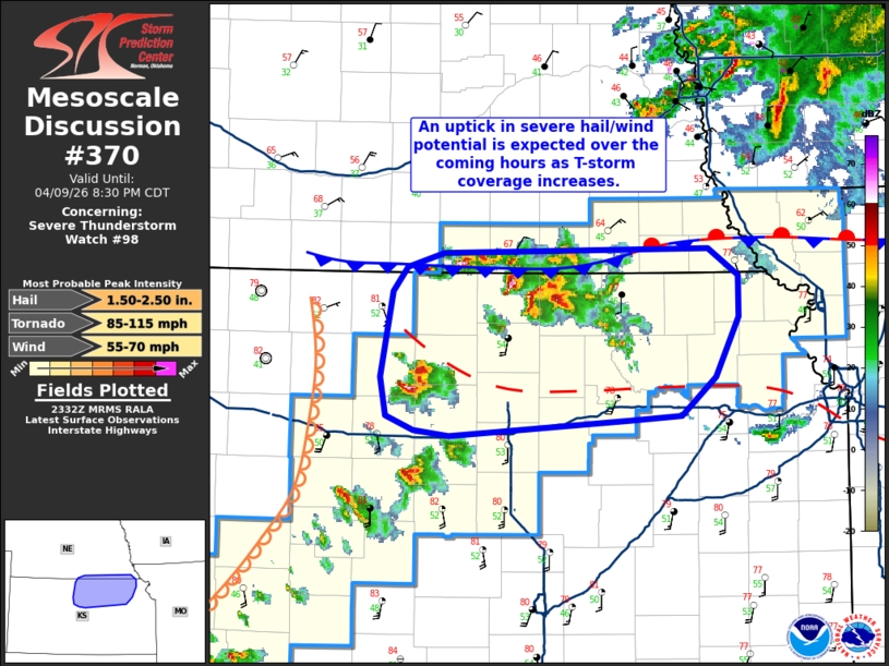 | |
Mesoscale Discussion 0370 NWS Storm Prediction Center Norman OK 0633 PM CDT Thu Apr 09 2026 Areas affected...Far southern Nebraska and portions of northern Kansas Concerning...Severe Thunderstorm Watch 98... Valid 092333Z - 100130Z The severe weather threat for Severe Thunderstorm Watch 98 continues. SUMMARY...The potential for severe hail and wind will continue to increase across north-central to northeast Kansas over the next couple of hours as thunderstorm coverage increases and clustering occurs. DISCUSSION...Latest GOES IR and radar trends across far northern KS and along the KS/NE border show an uptick in thunderstorm coverage amid a localized increase in low-level ascent driven by a combination of strengthening isentropic ascent (associated with a modest uptick in 0-3 km southerly winds per regional VWPs) and forcing along a localized southward surge of a frontal boundary (noted in KUEX reflectivity). More isolated developing supercells are also noted to the north of I-70, though somewhat weaker ascent away from the mesoscale boundaries has resulted in a more gradual intensification thus far. Regardless, based on recent RAP forecast soundings modified by local surface observations, MLCAPE values to the south of the primary synoptic boundary are likely between 1500-2000 J/kg downstream of the developing cells/clusters. With effective bulk shear values ranging 35-40 knots, the maintenance of discrete and semi-discrete supercells appears likely over the next hour or so with an attendant threat for severe hail. Hail stones between 1.5 and 1.75 inches in diameter have been recently noted with some of this activity, but the thermodynamic and kinematic environment appears supportive of hail up to 2 to 2.5 inches as along as discrete storm modes can be maintained. With time, eastward storm propagation and strengthening ascent at the terminus of an increasing low-level jet will promote additional thunderstorm development. High cloud bases near 2 km atop a somewhat deep/dry boundary layer are supporting strong downbursts per regional velocity data and live web cams. This trend suggests that convective outflows may be fairly widespread, and coupled with increasing ascent/storm coverage, will likely result in clustering and an increasing wind threat heading into the late evening hours downstream across northeast KS. ..Moore.. 04/09/2026 ...Please see www.spc.noaa.gov for graphic product... ATTN...WFO...OAX...TOP...ICT...GID... LAT...LON 38899849 39009874 39279880 39869869 40049856 40149823 40179583 39989557 39699557 39269578 38999609 38979655 38859817 38899849 MOST PROBABLE PEAK TORNADO INTENSITY...85-115 MPH MOST PROBABLE PEAK WIND GUST...55-70 MPH MOST PROBABLE PEAK HAIL SIZE...1.50-2.50 IN | |
| Top/All Mesoscale Discussions/Forecast Products/Home | |