|
|
| Mesoscale Discussion 227 | |
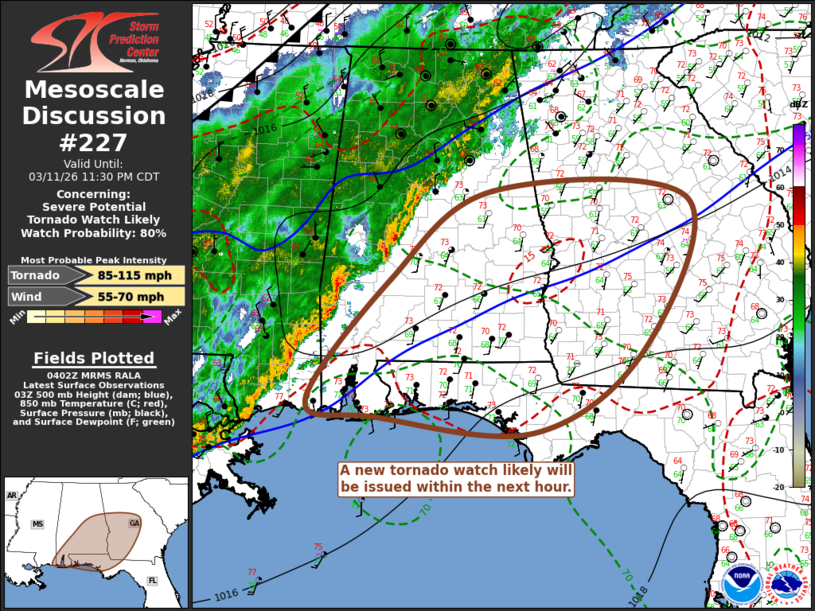 | |
   Mesoscale Discussion 0227
   NWS Storm Prediction Center Norman OK
   1104 PM CDT Wed Mar 11 2026

   Areas affected...parts of central and southern Alabama into
   central/southwestern Georgia and the Florida Panhandle

   Concerning...Severe potential...Tornado Watch likely

   Valid 120404Z - 120430Z

   Probability of Watch Issuance...80 percent

   SUMMARY...A new tornado watch will likely be issued within the next
   hour downstream of Tornado Watch 48.

   DISCUSSION...The organized convective system will likely begin to
   progress east of the Tornado Watch 48 within the next 1-2 hours.  It
   appears that at least weak continuing destabilization and forcing
   for ascent may maintain it with risk for occasional brief tornadoes
   and damaging wind gusts through at least 10-12Z.

   ..Kerr/Smith.. 03/12/2026

   ...Please see www.spc.noaa.gov for graphic product...

   ATTN...WFO...FFC...TAE...BMX...MOB...LIX...

   LAT...LON   33068293 31148362 30088527 30288763 30478864 32048741
               33178589 33068293

   MOST PROBABLE PEAK TORNADO INTENSITY...85-115 MPH
   MOST PROBABLE PEAK WIND GUST...55-70 MPH
| |
| Top/All Mesoscale Discussions/Forecast Products/Home | |