root@sleepynerdlive.com
:
~
$
cat $HOME/public_html/posts/storm-prediction-center-mesoscale-discussion-2261.txt >> story.html | parse_story story.html; rm -f storm-prediction-center-mesoscale-discussion-2261.txt story.html
|
|
| Mesoscale Discussion 2261 | |
|
|
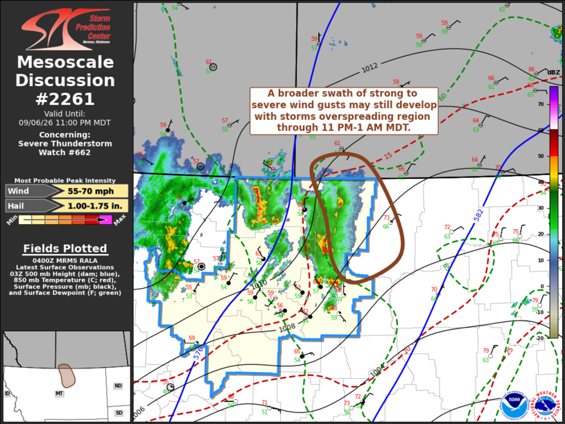
Mesoscale Discussion 2261 NWS Storm Prediction Center Norman OK 1102 PM CDT Sun Sep 06 2026 Areas affected...parts of north central Montana Concerning...Severe Thunderstorm Watch 662... Valid 070402Z - 070500Z The severe weather threat for Severe Thunderstorm Watch 662 continues. SUMMARY...Some further intensification of storms appears possible, perhaps including a small evolving organized cluster accompanied by strong surface gusts across the Malta through international border vicinity of north central Montana by 11 PM-1 AM MDT. DISCUSSION...A couple of stronger storms have generally maintained vigorous intensity over the past few hours while propagating north of Lewistown toward the international border, with supporting mid/upper forcing for ascent. Based on latest surface and objective analysis, mid 60s F surface dew points around the Malta vicinity may still provide potential for increasingly unstable updraft inflow over the next couple of hours. This could be accompanied by further thunderstorm intensification, perhaps including the evolution of a small organizing cluster with potential to produce a bit broader swath of strong to severe gusts. It appears that this probably will remain west of Glasgow, impacting mainly Blaine and Phillips counties before progressing across the international border overnight. ..Kerr.. 09/07/2026 ...Please see www.spc.noaa.gov for graphic product... ATTN...WFO...GGW...TFX... LAT...LON 47760914 48410931 49190961 49280852 48460779 47860775 47510868 47760914 MOST PROBABLE PEAK WIND GUST...55-70 MPH MOST PROBABLE PEAK HAIL SIZE...1.00-1.75 IN |
|
|
Top/All Mesoscale Discussions/Forecast Products/Home |
|