root@sleepynerdlive.com
:
~
$
cat $HOME/public_html/posts/storm-prediction-center-mesoscale-discussion-2256.txt >> story.html | parse_story story.html; rm -f storm-prediction-center-mesoscale-discussion-2256.txt story.html
|
|
| Mesoscale Discussion 2256 | |
|
|
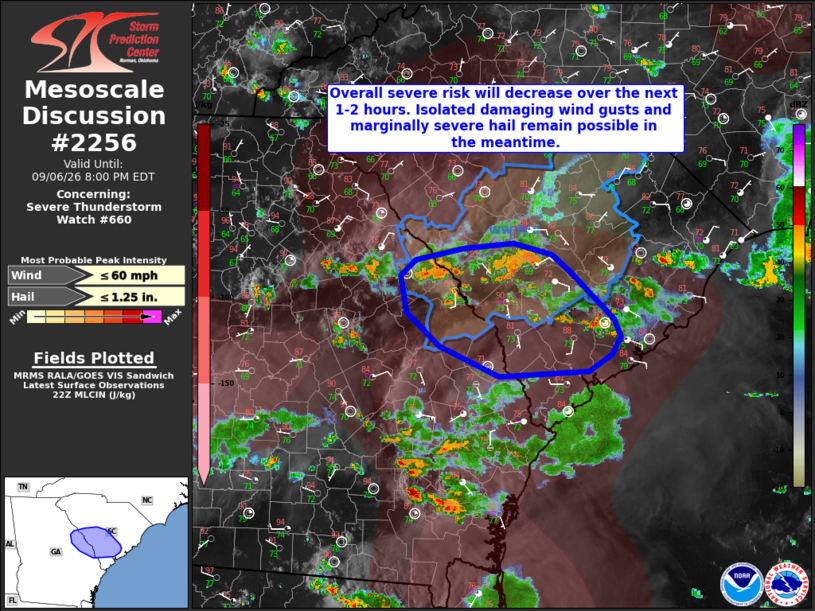
Mesoscale Discussion 2256 NWS Storm Prediction Center Norman OK 0600 PM CDT Sun Sep 06 2026 Areas affected...portions of southern South Carolina and far eastern Georgia Concerning...Severe Thunderstorm Watch 660... Valid 062300Z - 070000Z The severe weather threat for Severe Thunderstorm Watch 660 continues. SUMMARY...Isolated damaging wind gusts and marginally severe hail remain possible across portions of Severe Thunderstorm Watch 660, but the overall severe risk is gradually diminishing. DISCUSSION...Latest objective analysis indicates an increase in convective inhibition to the south of ongoing convection across southern/eastern South Carolina where surface temperatures have fallen into the 80s F amid widespread cloud cover, outflow from prior convection, and waning diurnal heating. This has resulted in a gradual weakening of ongoing convection, as noted via recent lighting trends, and a gradual decrease in the overall severe risk. While this risk will continue to decrease over the next 1-2 hours, isolated damaging wind gusts and perhaps an instance of marginally severe hail cannot be ruled out with the more robust cores in the meantime. ..Chalmers.. 09/06/2026 ...Please see www.spc.noaa.gov for graphic product... ATTN...WFO...CHS...CAE...FFC... LAT...LON 33108017 32938010 32768019 32598045 32548146 32848214 33158251 33508258 33668241 33768188 33828130 33708087 33548067 33108017 MOST PROBABLE PEAK WIND GUST...UP TO 60 MPH MOST PROBABLE PEAK HAIL SIZE...UP TO 1.25 IN |
|
|
Top/All Mesoscale Discussions/Forecast Products/Home |
|