root@sleepynerdlive.com
:
~
$
cat $HOME/public_html/posts/storm-prediction-center-mesoscale-discussion-2255.txt >> story.html | parse_story story.html; rm -f storm-prediction-center-mesoscale-discussion-2255.txt story.html
|
|
| Mesoscale Discussion 2255 | |
|
|
   Mesoscale Discussion 2255
   NWS Storm Prediction Center Norman OK
   0516 PM CDT Sun Sep 06 2026

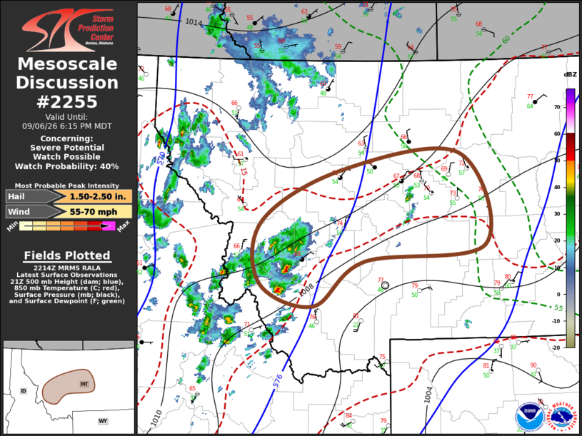
   Areas affected...west central through central Montana

   Concerning...Severe potential...Watch possible

   Valid 062216Z - 070015Z

   Probability of Watch Issuance...40 percent

   SUMMARY...The development of at least widely scattered storms
   capable of producing severe hail and wind appears increasingly
   probable through 6-8 PM MDT.  It remains unclear whether this will
   require a severe weather watch, but trends are being monitored for
   this possibility.

   DISCUSSION...Large-scale ascent, supported by lower/mid-tropospheric
   warm advection beneath strengthening difluent mid/upper flow,
   downstream of troughing slowly pivoting toward the northern Rockies,
   is contributing to the initiation of thunderstorm development across
   the mountains of west central into central Montana.  This is
   occurring in the presence of relatively cool thermodynamic profiles,
   but with sufficiently steep lapse rates to support at least modest
   CAPE on the order of 500-1000 J/kg.   Coupled with the presence of
   strong deep-layer shear beneath 40-70+ southwesterly flow in the
   500-300 mb layer, the environment appears conducive to the evolution
   of at least widely scattered supercells capable of producing severe
   hail and severe wind gusts through 00-02Z.  The extent to which
   activity may grow upscale into a least small organizing clusters
   with more widespread damaging wind gust potential remains a bit more
   unclear, and will continue to be monitored.

   ..Kerr/Smith.. 09/06/2026

   ...Please see www.spc.noaa.gov for graphic product...

   ATTN...WFO...BYZ...TFX...MSO...

   LAT...LON   46681372 47421207 47680959 46340906 46121158 45461263
               45781374 46681372

   MOST PROBABLE PEAK WIND GUST...55-70 MPH
   MOST PROBABLE PEAK HAIL SIZE...1.50-2.50 IN
|
|
|
Top/All Mesoscale Discussions/Forecast Products/Home |
|