root@sleepynerdlive.com
:
~
$
cat $HOME/public_html/posts/storm-prediction-center-mesoscale-discussion-2254.txt >> story.html | parse_story story.html; rm -f storm-prediction-center-mesoscale-discussion-2254.txt story.html
|
|
| Mesoscale Discussion 2254 | |
|
|
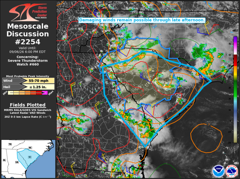
Mesoscale Discussion 2254 NWS Storm Prediction Center Norman OK 0332 PM CDT Sun Sep 06 2026 Areas affected...SC into eastern GA Concerning...Severe Thunderstorm Watch 660... Valid 062032Z - 062200Z The severe weather threat for Severe Thunderstorm Watch 660 continues. SUMMARY...Damaging winds remain possible through late afternoon. DISCUSSION...Scattered storms are ongoing this afternoon across much of SC into eastern GA. MLCAPE of greater than 2000 J/kg and steep low-level lapse rates will continue to support wind-damage potential with the strongest storms through late afternoon. Longer-lived convection across Upstate SC has developed a larger-scale outflow, which will favor continued development along the gust front and a threat for scattered damaging winds spreading southeastward into the SC Midlands through late afternoon. Localized wind-damage potential will also continue to accompany other areas of ongoing storms, with additional development possible within the weakly capped environment. ..Dean.. 09/06/2026 ...Please see www.spc.noaa.gov for graphic product... ATTN...WFO...ILM...CHS...CAE...GSP...FFC... LAT...LON 34488327 34748208 35088151 35048109 34968082 34748039 34467922 33937846 33737881 33447910 33257929 32967965 32618015 32228072 31548136 32738252 32968284 33458317 34488327 MOST PROBABLE PEAK WIND GUST...55-70 MPH MOST PROBABLE PEAK HAIL SIZE...UP TO 1.25 IN |
|
|
Top/All Mesoscale Discussions/Forecast Products/Home |
|