root@sleepynerdlive.com
:
~
$
cat $HOME/public_html/posts/storm-prediction-center-mesoscale-discussion-2246.txt >> story.html | parse_story story.html; rm -f storm-prediction-center-mesoscale-discussion-2246.txt story.html
|
|
| Mesoscale Discussion 2246 | |
|
|
   Mesoscale Discussion 2246
   NWS Storm Prediction Center Norman OK
   0440 PM CDT Sat Sep 05 2026

   Areas affected...portions of southern and coastal South Carolina
   into far eastern Georgia

   Concerning...Severe potential...Watch possible

   Valid 052140Z - 052315Z

   Probability of Watch Issuance...60 percent

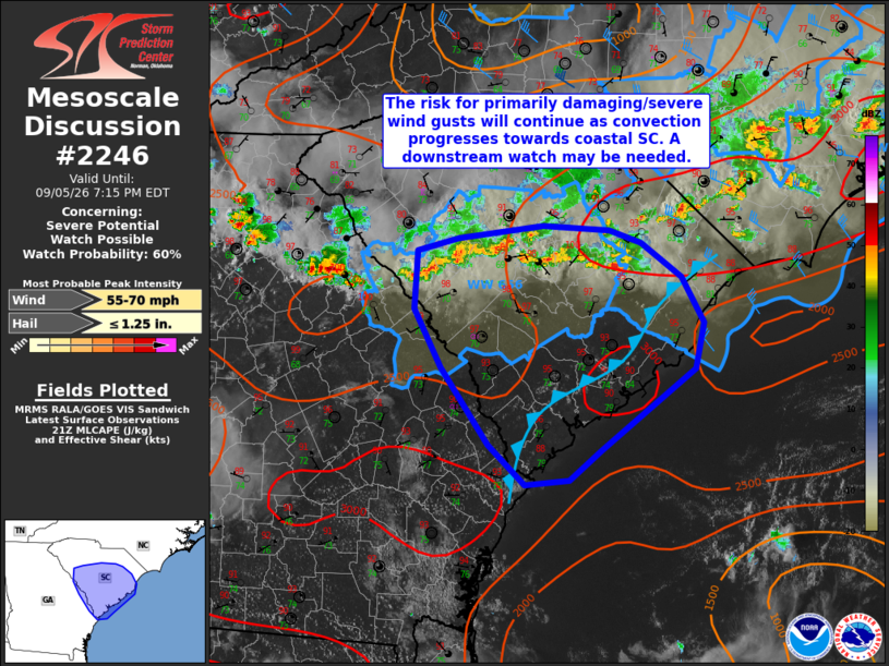
   SUMMARY...A risk for primarily damaging/severe wind gusts is
   expected to continue as ongoing thunderstorms evolve southeastward
   toward the SC coast. A downstream Severe Thunderstorm Watch may be
   needed in the next hour.

   DISCUSSION...Regional radar imagery depicts a broken band of
   convection extending from northeast of the Atlanta Metro into far
   southeastern North Carolina as of 2140 UTC. Occasionally stronger
   downburst signatures have been noted within the marginally more
   well-organized linear segments, and several reports of
   damaging/severe wind gusts have been noted, including a measured 63
   kt (72 mph) wind gust at KFAY at 2048 UTC. The environment
   downstream of ongoing convection in central SC is not too dissimilar
   to areas farther northeast, with MLCAPE of 2500-3000+ J/kg, modestly
   steep low-level lapse rates (particularly inland of the sea breeze),
   and high PW around 2". Combined with modest effective shear of 25-30
   kts, this environment should continue to favor loosely organized
   convective clusters and the potential for water-loaded downbursts
   capable of damaging/severe wind gusts as convection progresses
   southeastward towards the South Carolina coastline. Convective
   trends will continue to be monitored, and a small Severe
   Thunderstorm Watch may be needed downstream within the next hour.

   ..Chalmers/Smith.. 09/05/2026

   ...Please see www.spc.noaa.gov for graphic product...

   ATTN...WFO...ILM...CHS...CAE...GSP...

   LAT...LON   34118163 34228075 34188006 34077972 33787931 33387907
               32977917 32278015 32018048 31978094 32328132 32988181
               33508209 34018205 34118163

   MOST PROBABLE PEAK WIND GUST...55-70 MPH
   MOST PROBABLE PEAK HAIL SIZE...UP TO 1.25 IN
|
|
|
Top/All Mesoscale Discussions/Forecast Products/Home |
|