root@sleepynerdlive.com
:
~
$
cat $HOME/public_html/posts/storm-prediction-center-mesoscale-discussion-2245.txt >> story.html | parse_story story.html; rm -f storm-prediction-center-mesoscale-discussion-2245.txt story.html
|
|
| Mesoscale Discussion 2245 | |
|
|
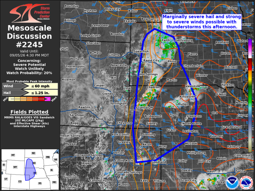
   Mesoscale Discussion 2245
   NWS Storm Prediction Center Norman OK
   0334 PM CDT Sat Sep 05 2026

   Areas affected...western/central South Dakota into western/central
   Nebraska and eastern Colorado

   Concerning...Severe potential...Watch unlikely

   Valid 052034Z - 052230Z

   Probability of Watch Issuance...20 percent

   SUMMARY...Isolated storms may produce marginally severe hail and
   strong to severe wind this afternoon/evening.

   DISCUSSION...Thunderstorms are developing near the surface trough
   across the central Plains. Modifying the 18z sounding from LBF shows
   MLCIN has weakened but remains.  Moderate instability was sampled
   above the capping layer. Remaining MLCIN is also depicted in SPC
   Mesoanalysis across much of the central Plains, though temperatures
   warming into the mid 90s across western Nebraska and eastern
   Colorado are slowly eroding the remaining cap. Deep layer flow is
   generally weak, which will likely keep the organized severe
   potential low. However, deep layer shear around 20-30 kts may
   support a few stronger cores capable of marginally severe hail.
   Large dew point depressions and steep lapse rates will favor outflow
   dominant storms capable of a few instances of strong to severe wind.
   Overall, severe potential looks to remain too isolated for watch
   issuance.

   ..Thornton/Gleason.. 09/05/2026

   ...Please see www.spc.noaa.gov for graphic product...

   ATTN...WFO...ABR...GID...LBF...UNR...GLD...BOU...CYS...

   LAT...LON   39410352 41030377 42140364 42920356 45060320 45400295
               45640247 45270123 44770090 44140078 44070082 43830063
               43330034 42329983 41769988 40510035 39520239 39410352

   MOST PROBABLE PEAK WIND GUST...UP TO 60 MPH
   MOST PROBABLE PEAK HAIL SIZE...UP TO 1.25 IN
|
|
|
Top/All Mesoscale Discussions/Forecast Products/Home |
|