root@sleepynerdlive.com
:
~
$
cat $HOME/public_html/posts/storm-prediction-center-mesoscale-discussion-2239.txt >> story.html | parse_story story.html; rm -f storm-prediction-center-mesoscale-discussion-2239.txt story.html
|
|
| Mesoscale Discussion 2239 | |
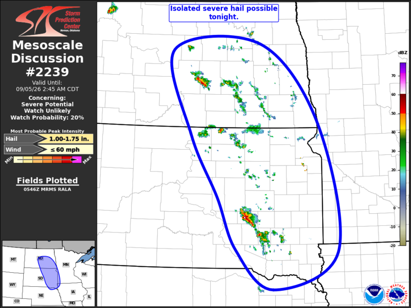
|
|
   Mesoscale Discussion 2239
   NWS Storm Prediction Center Norman OK
   1248 AM CDT Sat Sep 05 2026

   Areas affected...Eastern Dakotas...Far Southwest MN...Far Northeast
   NE

   Concerning...Severe potential...Watch unlikely

   Valid 050548Z - 050745Z

   Probability of Watch Issuance...20 percent

   SUMMARY...Isolated severe thunderstorms capable of large hail are
   possible across the eastern Dakota tonight.

   DISCUSSION...Thunderstorms coverage and intensity continues to
   increase across the eastern Dakotas. These thunderstorms are
   developing within a zone of low to mid-level warm-air advection
   along the eastern periphery of an extensive low-level jet stretching
   from western KS through the western Dakotas. The airmass across the
   region is moderately to strongly unstable, with mesoanalysis
   estimating MUCAPE ranging from 3500 J/kg over southeast SD to 1500
   J/kg across southeast ND. This buoyancy gradient matches what was
   observed by the regional 00Z soundings, where OAX sampled over 5000
   J/kg of MUCAPE while ABR and BIS were closer to 2000 J/kg. A belt of
   moderate to strong effective bulk shear extends from western ND into
   southeast SD as well.

   The resulting combination of buoyancy and shear will support
   organized storm structures, and large hail will be possible with any
   more mature updraft. Primary severe potential is expected over SD
   where the strongest vertical shear exists. Overall severe
   thunderstorm coverage is currently expected to stay isolated, likely
   precluding the need for a watch. However, convective trends are
   being monitored closely.

   ..Mosier.. 09/05/2026

   ...Please see www.spc.noaa.gov for graphic product...

   ATTN...WFO...MPX...FGF...FSD...OAX...ABR...BIS...LBF...

   LAT...LON   45770030 47550086 47689824 45999653 43339602 42549789
               43389897 44479951 45770030

   MOST PROBABLE PEAK WIND GUST...UP TO 60 MPH
   MOST PROBABLE PEAK HAIL SIZE...1.00-1.75 IN
|
|
|
Top/All Mesoscale Discussions/Forecast Products/Home |
|