root@sleepynerdlive.com
:
~
$
cat $HOME/public_html/posts/storm-prediction-center-mesoscale-discussion-2236.txt >> story.html | parse_story story.html; rm -f storm-prediction-center-mesoscale-discussion-2236.txt story.html
|
|
| Mesoscale Discussion 2236 | |
|
|
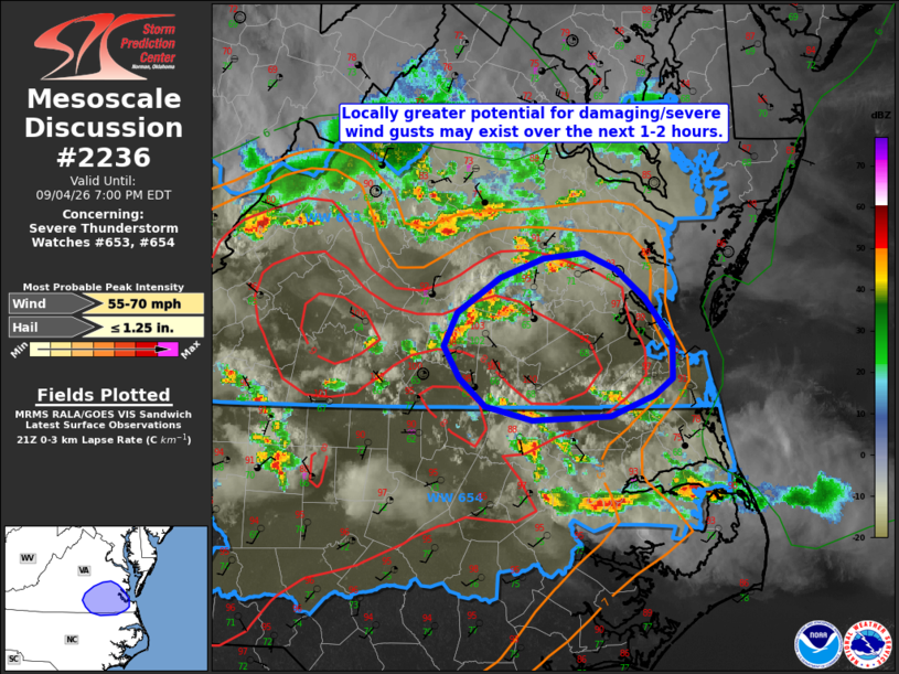
Mesoscale Discussion 2236 NWS Storm Prediction Center Norman OK 0455 PM CDT Fri Sep 04 2026 Areas affected...portions of southeastern Virginia into far northeastern North Carolina Concerning...Severe Thunderstorm Watch 653...654... Valid 042155Z - 042300Z The severe weather threat for Severe Thunderstorm Watch 653, 654 continues. SUMMARY...A corridor of locally greater damaging/severe wind gust risk may exist across far southeastern Virginia and far northeastern North Carolina over the next 1-2 hours. DISCUSSION...Regional radar imagery depicts scattered thunderstorms ongoing across portions of the Mid-Atlantic, with several reports of wind damage and an isolated instance of severe hail noted over the past hour in association with a cluster of storms located in the vicinity of Richmond, VA. Latest objective analysis and surface observations indicate the air mass ahead of this cluster remains relatively undisturbed, with moderate to strong buoyancy and steep low-level lapse rates in place. 30-40 kts of effective shear will continue to support a mix of transient supercell structures and linear clusters, which is also supported by recent HRRR/RRFS runs. Thus, a localized corridor of greater damaging/severe wind gust potential is likely to exist across this area over the next 1-2 hours. ..Chalmers.. 09/04/2026 ...Please see www.spc.noaa.gov for graphic product... ATTN...WFO...AKQ...RAH... LAT...LON 37337653 37017628 36757628 36627644 36487683 36447753 36547794 36747818 36977831 37217820 37467781 37617742 37657706 37537677 37337653 MOST PROBABLE PEAK WIND GUST...55-70 MPH MOST PROBABLE PEAK HAIL SIZE...UP TO 1.25 IN |
|
|
Top/All Mesoscale Discussions/Forecast Products/Home |
|