root@sleepynerdlive.com
:
~
$
cat $HOME/public_html/posts/storm-prediction-center-mesoscale-discussion-2230.txt >> story.html | parse_story story.html; rm -f storm-prediction-center-mesoscale-discussion-2230.txt story.html
|
|
| Mesoscale Discussion 2230 | |
|
|
   Mesoscale Discussion 2230
   NWS Storm Prediction Center Norman OK
   0208 AM CDT Fri Sep 04 2026

   Areas affected...portions of eastern Wisconsin

   Concerning...Severe potential...Watch unlikely

   Valid 040708Z - 040845Z

   Probability of Watch Issuance...20 percent

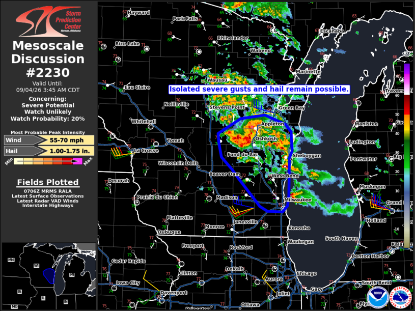
   SUMMARY...A cluster of supercells will likely persist for another
   couple of hours before moving offshore. Severe gusts and some hail
   are possible.

   DISCUSSION...As of 0705 UTC, local radar imagery showed a cluster of
   strong to severe storms ongoing from east-central WI toward the Lake
   Michigan Coast. Aided by low-level warm advection at the terminus of
   a southwesterly low-level jet, these storms are likely elevated,
   being supported by 2000-3000 J/kg of MUCAPE. The large buoyancy and
   40-50 kt of northwesterly deep-layer shear will likely maintain
   storm organization/intensity for a few hours before convection moves
   over the lake.

   Variable storm mode has been noted with both supercells and some
   clustering evident. The strongest cluster (Winnebago and Waushara
   Counties) has shown some increase in forward speed along with
   upscale growth. Gradual coalescence should continue as new updrafts
   have been observe developing along outflow and near the lake shore
   which may be aiding in localized convergence. This suggests some
   increase in damaging/severe gusts may occur. Exactly how much risk
   develops is unclear given that the boundary layer is stable (temps
   in the 60s to 70s F) and these storms remain elevated. Still, some
   severe gusts are possible, along with a risk for hail given the
   large buoyancy and supercells. Current expectations are for the
   severe risk to remain isolated enough that a Watch likely wont be
   needed. However, convective trends will be monitored if a more
   organized/persistent severe risk becomes apparent.

   ..Lyons/Mosier.. 09/04/2026

   ...Please see www.spc.noaa.gov for graphic product...

   ATTN...WFO...GRB...MKX...

   LAT...LON   42998842 43428887 43598904 43788926 43998933 44168934
               44408884 44468830 44308784 44188771 43888769 43778775
               43518777 43158778 43008781 42908791 42918825 42998842

   MOST PROBABLE PEAK WIND GUST...55-70 MPH
   MOST PROBABLE PEAK HAIL SIZE...1.00-1.75 IN
|
|
|
Top/All Mesoscale Discussions/Forecast Products/Home |
|