root@sleepynerdlive.com
:
~
$
cat $HOME/public_html/posts/storm-prediction-center-mesoscale-discussion-2229.txt >> story.html | parse_story story.html; rm -f storm-prediction-center-mesoscale-discussion-2229.txt story.html
|
|
| Mesoscale Discussion 2229 | |
|
|
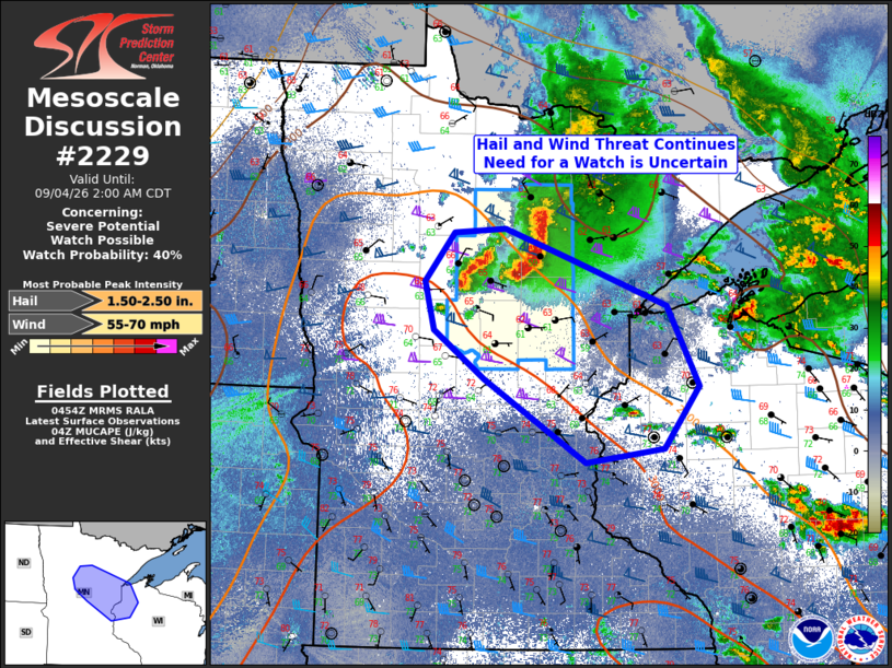
   Mesoscale Discussion 2229
   NWS Storm Prediction Center Norman OK
   1155 PM CDT Thu Sep 03 2026

   Areas affected...portions of northern Minnesota into northwest
   Wisconsin

   Concerning...Severe potential...Watch possible

   Valid 040455Z - 040700Z

   Probability of Watch Issuance...40 percent

   SUMMARY...Hail and wind threat will continue late this evening into
   the overnight hours associated with the southern portions of a
   north-to-south linear thunderstorm complex. Trends are being
   assessed for potential downstream watch issuance across portions of
   Minnesota and Wisconsin.

   DISCUSSION...A long-lived linear thunderstorm cluster continues to
   move east across northern Minnesota this evening. This thunderstorm
   cluster is likely ingesting elevated but very unstable air parcels
   originating within an MUCAPE reservoir across central Minnesota
   where MUCAPE values in excess of 3500 J/kg exists. To the east of
   this thunderstorm complex, a convectively overturned and Lake
   Superior modified airmass is in place, with surface temperatures in
   the 60Fs and dewpoints in the 50Fs.

   Recent radar trends indicate a turn toward the southeast is underway
   as the complex crests the MUCAPE axis and now rides southeast along
   the MUCAPE gradient. This southeastward turn would seemingly
   indicate some surface-based cold pool development and some potential
   for damaging winds despite the weak low-level lapse rates.
   Additionally, MRMS MESH swaths have increased in coverage area,
   although not necessarily consistently increased in intensity.

   Environmentally speaking, the better airmass for severe potential
   exists farther southeast -- across east-central Minnesota and
   northwest Wisconsin where surface temperatures and surface dewpoint
   temperatures about 5-10 F warmer. Should it become apparent that the
   ongoing thunderstorm cluster will realize this better downstream
   airmass, a new severe thunderstorm watch may be needed. However,
   whether this occurs remains uncertain. As such, a local extension of
   Severe Thunderstorm Watch 651 will be needed as trends are monitored
   for downstream watch needs.

   ..Marsh/Smith.. 09/04/2026

   ...Please see www.spc.noaa.gov for graphic product...

   ATTN...WFO...DLH...MPX...FGF...

   LAT...LON   46979509 47439469 47489398 47219314 46749178 45999134
               45399182 45269288 46059427 46519495 46979509

   MOST PROBABLE PEAK WIND GUST...55-70 MPH
   MOST PROBABLE PEAK HAIL SIZE...1.50-2.50 IN
|
|
|
Top/All Mesoscale Discussions/Forecast Products/Home |
|