root@sleepynerdlive.com
:
~
$
cat $HOME/public_html/posts/storm-prediction-center-mesoscale-discussion-2227.txt >> story.html | parse_story story.html; rm -f storm-prediction-center-mesoscale-discussion-2227.txt story.html
|
|
| Mesoscale Discussion 2227 | |
|
|
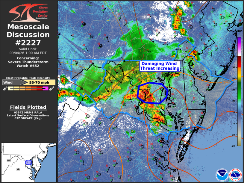
Mesoscale Discussion 2227 NWS Storm Prediction Center Norman OK 1056 PM CDT Thu Sep 03 2026 Areas affected...northern Virginia and central Maryland Concerning...Severe Thunderstorm Watch 652... Valid 040356Z - 040500Z The severe weather threat for Severe Thunderstorm Watch 652 continues. SUMMARY...Damaging wind threat is increasing for the greater Washington D.C. area. DISCUSSION...Rapid thunderstorm development occurred late this evening in the vicinity of Washington D.C. Here, warm-air advection thunderstorms combined with increasing convergence from an outflow boundary from an earlier storm. The result has been a rapid increase in hydrometeors aloft, which will support heavy water loaded downdrafts/downbursts capable of wind damage across the greater Washington D.C. area. At 0348Z Washington National airport measured a 64 mph wind gust. This threat will continue to move east over the next hour. ..Marsh.. 09/04/2026 ...Please see www.spc.noaa.gov for graphic product... ATTN...WFO...PHI...LWX... LAT...LON 39067724 39157691 39117648 38947629 38777634 38617657 38647704 38767728 39067724 MOST PROBABLE PEAK WIND GUST...55-70 MPH |
|
|
Top/All Mesoscale Discussions/Forecast Products/Home |
|