root@sleepynerdlive.com
:
~
$
cat $HOME/public_html/posts/storm-prediction-center-mesoscale-discussion-2225.txt >> story.html | parse_story story.html; rm -f storm-prediction-center-mesoscale-discussion-2225.txt story.html
|
|
| Mesoscale Discussion 2225 | |
|
|
   Mesoscale Discussion 2225
   NWS Storm Prediction Center Norman OK
   0744 PM CDT Thu Sep 03 2026

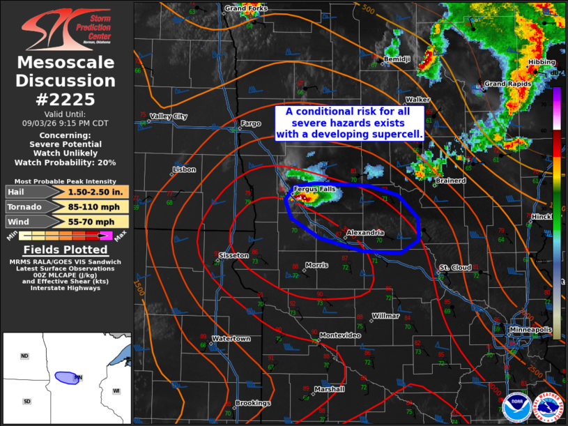
   Areas affected...portions of west-central Minnesota

   Concerning...Severe potential...Watch unlikely

   Valid 040044Z - 040215Z

   Probability of Watch Issuance...20 percent

   SUMMARY...Isolated supercells may pose a risk for all severe hazards
   over the next 1-2 hours.

   DISCUSSION...Two isolated supercells have recently developed in
   close proximity to a surface low analyzed near the ND/SD/MN border.
   While the northern supercell has since dissipated, recent HRRR/RRFS
   solutions have captured this activity well and suggest that at least
   an isolated supercell may persist east-southeastward over the next
   1-2 hours before eventually weakening due to nocturnal low-level
   stabilization. While the temporal aspect of this scenario remains
   somewhat uncertain, a conditional risk for all severe hazards exists
   in the short-term. Latest objective analysis depicts effective shear
   of 50-60 kts overlapping an MLCAPE bullseye of 3500 J/kg as well as
   steep low- and mid-level lapse rates, supportive of large to very
   large hail (perhaps 2+ inches in diameter) and severe wind gusts.
   Backed surface winds within the warm sector and modestly enhanced
   low-level shear along a weak surface stationary/warm front will also
   support the risk for perhaps a tornado. The overall severe risk is
   expected to remain confined both spatially and temporally. Thus,
   watch issuance appears unlikely at this time.

   ..Chalmers/Smith.. 09/04/2026

   ...Please see www.spc.noaa.gov for graphic product...

   ATTN...WFO...MPX...FGF...

   LAT...LON   46349604 46379579 46369507 46279467 46059441 45869440
               45739464 45759515 45879571 46059608 46239616 46349604

   MOST PROBABLE PEAK TORNADO INTENSITY...85-110 MPH
   MOST PROBABLE PEAK WIND GUST...55-70 MPH
   MOST PROBABLE PEAK HAIL SIZE...1.50-2.50 IN
|
|
|
Top/All Mesoscale Discussions/Forecast Products/Home |
|