root@sleepynerdlive.com
:
~
$
cat $HOME/public_html/posts/storm-prediction-center-mesoscale-discussion-2194.txt >> story.html | parse_story story.html; rm -f storm-prediction-center-mesoscale-discussion-2194.txt story.html
|
|
| Mesoscale Discussion 2194 | |
|
|
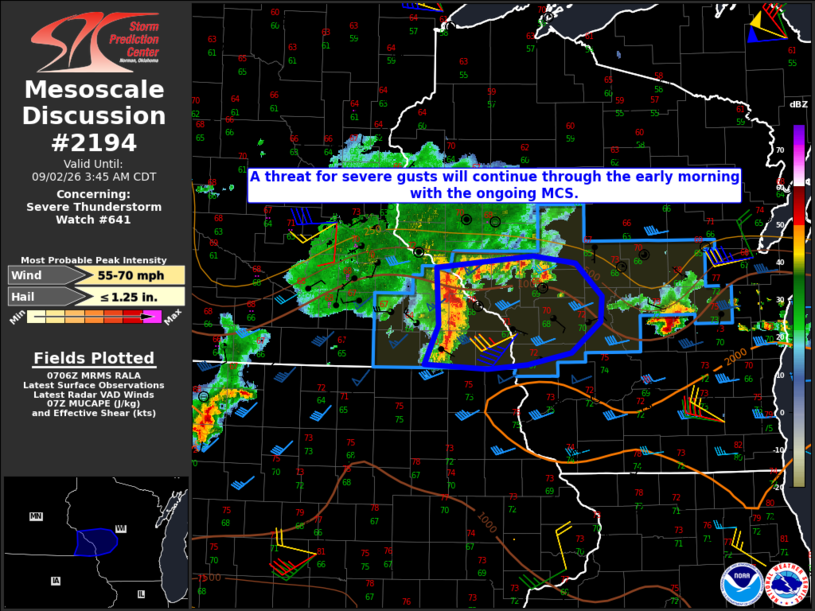
Mesoscale Discussion 2194 NWS Storm Prediction Center Norman OK 0208 AM CDT Wed Sep 02 2026 Areas affected...Southeast MN into west-central WI Concerning...Severe Thunderstorm Watch 641... Valid 020708Z - 020845Z The severe weather threat for Severe Thunderstorm Watch 641 continues. SUMMARY...A threat for severe gusts will continue through the early morning with an ongoing MCS. DISCUSSION...A compact but long-lived and well-organized MCS is moving across southeast MN early this morning. This MCS recently produced gusts of 60-70 mph in the Rochester, MN area, and relatively strong inbound velocities continue to be observed from the KARX radar. Given its current organization and favorable deep-layer shear noted from the KARX VWP, this MCS will likely continue to pose a short-term threat for severe gusts as it approaches west-central WI. With time, this MCS will begin to encounter a less favorable thermodynamic environment, as it moves into a region increasingly influenced by outflow from downstream convection. As a result, the longevity of severe-wind potential is uncertain, but at least some threat for wind damage with the ongoing MCS may eventually reach eastern portions of WW 641. ..Dean.. 09/02/2026 ...Please see www.spc.noaa.gov for graphic product... ATTN...WFO...GRB...ARX...MPX... LAT...LON 44439223 44549098 44489043 44179009 43929010 43649049 43529106 43489156 43529238 43909221 44439223 MOST PROBABLE PEAK WIND GUST...55-70 MPH MOST PROBABLE PEAK HAIL SIZE...UP TO 1.25 IN |
|
|
Top/All Mesoscale Discussions/Forecast Products/Home |
|