root@sleepynerdlive.com
:
~
$
cat $HOME/public_html/posts/storm-prediction-center-mesoscale-discussion-2193.txt >> story.html | parse_story story.html; rm -f storm-prediction-center-mesoscale-discussion-2193.txt story.html
|
|
| Mesoscale Discussion 2193 | |
|
|
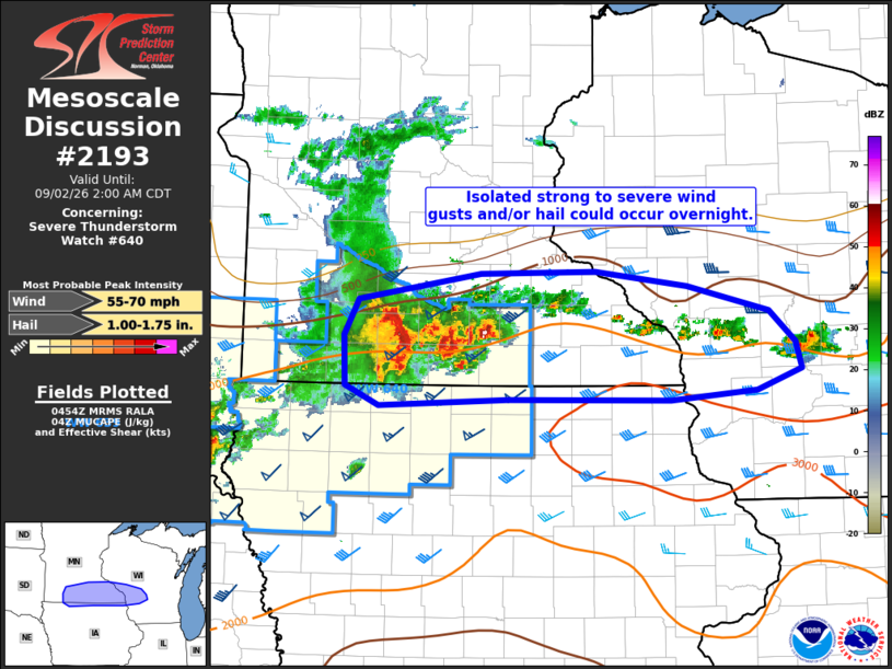
Mesoscale Discussion 2193 NWS Storm Prediction Center Norman OK 1156 PM CDT Tue Sep 01 2026 Areas affected...portions of southern MN into western WI Concerning...Severe Thunderstorm Watch 640... Valid 020456Z - 020700Z The severe weather threat for Severe Thunderstorm Watch 640 continues. SUMMARY...Thunderstorm clusters could continue to produce strong to severe wind gusts and hail into the overnight hours. A downstream watch into parts of southeast Minnesota and western Wisconsin is uncertain, but a small downstream watch may be needed depending on storm trends. DISCUSSION...A cluster of storms over southern MN has weakened some over the past 30-60 minutes as it has continued to lift northeast. With this storm motion, convection has shifted further away from the modest low-level jet oriented across IA, and northward into more modest instability and midlevel lapse rates. Most recent observed wind gusts have generally been in the 40-55 mph range, with 1.75 inch hail reported nearly an hour ago. Overall convective organization has become more messy with time. Given overall environment, sporadic severe wind gusts or hail could persist into the overnight hours across southeast MN and perhaps west-central WI. Damaging wind potential could increase if the cluster can track more easterly near a surface boundary across southern MN. Depending on short term trends, a small downstream watch could become necessary, but remains uncertain. ..Leitman.. 09/02/2026 ...Please see www.spc.noaa.gov for graphic product... ATTN...WFO...MKX...ARX...MPX...DMX...FSD... LAT...LON 43919524 44239508 44469362 44479226 44349118 44139021 43858990 43638982 43449035 43379137 43379330 43319483 43489522 43919524 MOST PROBABLE PEAK WIND GUST...55-70 MPH MOST PROBABLE PEAK HAIL SIZE...1.00-1.75 IN |
|
|
Top/All Mesoscale Discussions/Forecast Products/Home |
|