root@sleepynerdlive.com
:
~
$
cat $HOME/public_html/posts/storm-prediction-center-mesoscale-discussion-2189.txt >> story.html | parse_story story.html; rm -f storm-prediction-center-mesoscale-discussion-2189.txt story.html
|
|
| Mesoscale Discussion 2189 | |
|
|
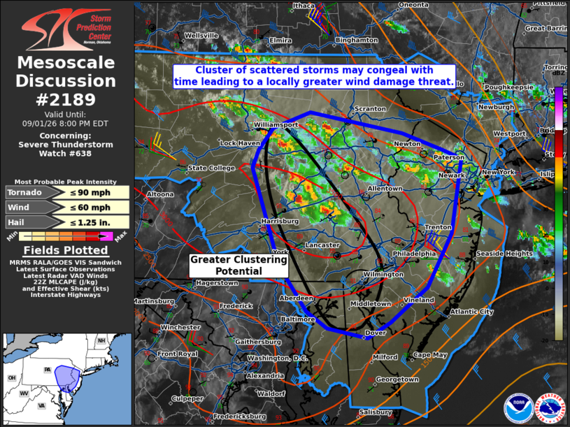
Mesoscale Discussion 2189 NWS Storm Prediction Center Norman OK 0532 PM CDT Tue Sep 01 2026 Areas affected...East-central/southeast Pennsylvania and New Jersey into the DelMarVa Concerning...Severe Thunderstorm Watch 638... Valid 012232Z - 020000Z The severe weather threat for Severe Thunderstorm Watch 638 continues. SUMMARY...A cluster of supercells may eventually grow upscale this evening. This will be the focus for the greatest damaging wind/large hail risk over the next 1-2 hours. DISCUSSION...Scattered convection in southeast Pennsylvania has some potential to congeal early this evening. The propagation of this cluster will likely be somewhat skewed to the west given the greater buoyancy present in south-central Pennsylvania. This activity will probably track towards the DelMarVa with time. Farther east, activity has increased over the last hour, though it has remained more cellular. Temperatures near the coast are slightly cooler. Wind damage will remain possible with all activity this evening. The greatest potential for wind damage (and marginally severe hail) will be with the westernmost storms. ..Wendt.. 09/01/2026 ...Please see www.spc.noaa.gov for graphic product... ATTN...WFO...OKX...PHI...BGM...CTP...LWX... LAT...LON 39247599 39417627 39877663 40857699 41047691 41257672 41417623 41207501 41037447 40957422 40197437 39657468 39307516 39147547 39247599 MOST PROBABLE PEAK TORNADO INTENSITY...UP TO 90 MPH MOST PROBABLE PEAK WIND GUST...UP TO 60 MPH MOST PROBABLE PEAK HAIL SIZE...UP TO 1.25 IN |
|
|
Top/All Mesoscale Discussions/Forecast Products/Home |
|