root@sleepynerdlive.com
:
~
$
cat $HOME/public_html/posts/storm-prediction-center-mesoscale-discussion-2188.txt >> story.html | parse_story story.html; rm -f storm-prediction-center-mesoscale-discussion-2188.txt story.html
|
|
| Mesoscale Discussion 2188 | |
| Next MD > | |
|
|
   Mesoscale Discussion 2188
   NWS Storm Prediction Center Norman OK
   0519 PM CDT Tue Sep 01 2026

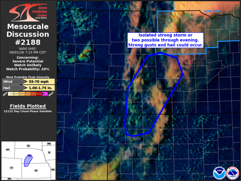
   Areas affected...portions of northwest KS into central NE

   Concerning...Severe potential...Watch unlikely

   Valid 012219Z - 020015Z

   Probability of Watch Issuance...20 percent

   SUMMARY...A strong storm or two could develop over the next couple
   of hours from northwest Kansas into central Nebraska. If a storm can
   develop and become sustained, strong wind gusts and hail could
   occur. Given uncertainty in storm development/coverage, a watch is
   not currently anticipated.

   DISCUSSION...Scattered towering cumulus are evident in visible
   satellite imagery late this afternoon along a modest surface
   trough/low-level convergence zone to the south of Severe
   Thunderstorm Watch 639. Vertical shear weakens with southwest extent
   from central NE into northwest KS. However, weak to moderate
   instability overlaps a moist boundary layer. Large-scale ascent will
   remain focused to the north of the region, but modest low-level
   convergence within the sufficiently unstable airmass may support a
   storm or two through evening. If a storm can develop and become
   sustained eastward off the surface trough and into deeper boundary
   layer moisture, damaging gusts and hail would be possible.
   Convection has been slow to develop with multiple failed attempts at
   initiation noted in satellite loops. Given uncertainty in storm
   development/coverage, watch issuance and/or southwest extension of
   Severe Thunderstorm Watch 639 is not currently anticipated.

   ..Leitman/Mosier.. 09/01/2026

   ...Please see www.spc.noaa.gov for graphic product...

   ATTN...WFO...GID...LBF...GLD...

   LAT...LON   39680142 40760132 41690055 41780006 41649943 41159920
               40539970 39450052 39350111 39410136 39680142

   MOST PROBABLE PEAK WIND GUST...55-70 MPH
   MOST PROBABLE PEAK HAIL SIZE...1.00-1.75 IN
|
|
|
Top/All Mesoscale Discussions/Forecast Products/Home |
|