root@sleepynerdlive.com
:
~
$
cat $HOME/public_html/posts/storm-prediction-center-mesoscale-discussion-2186.txt >> story.html | parse_story story.html; rm -f storm-prediction-center-mesoscale-discussion-2186.txt story.html
|
|
| Mesoscale Discussion 2186 | |
|
|
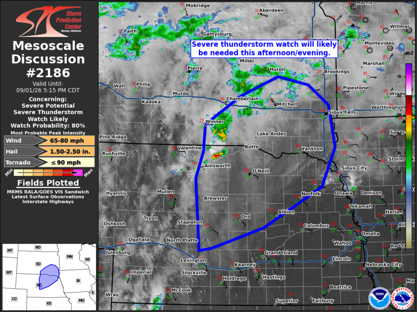
   Mesoscale Discussion 2186
   NWS Storm Prediction Center Norman OK
   0317 PM CDT Tue Sep 01 2026

   Areas affected...north-central to northeast Nebraska into
   south-central to southeast South Dakota.

   Concerning...Severe potential...Severe Thunderstorm Watch likely

   Valid 012017Z - 012215Z

   Probability of Watch Issuance...80 percent

   SUMMARY...A severe thunderstorm watch will likely be needed this
   afternoon/evening across parts of northeast Nebraska and southeast
   South Dakota and vicinity.

   DISCUSSION...Weak elevated convection has been persistent across
   north-central Nebraska for much of the day. Recently, the cu-field
   across north-central Nebraska has started to expand, consistent with
   the erosion of MLCIN from SPC mesoanalysis. A weak mid-level
   shortwave trough, currently across eastern Colorado and the Nebraska
   Panhandle, will advance east through the evening with weak ascent
   overspreading the uncapped warm sector. In addition, the low-level
   jet will strengthen through the evening and into the overnight hours
   which will lead to additional ascent across the region. Moderate to
   strong instability, combined with 50 to 55 knots of effective shear
   will support supercell storm mode initially with some threat for
   very large hail and 75+ mph wind gusts. As storms grow upscale, a
   more focused corridor of severe wind gusts may develop near the
   NE/SD border into the evening.

   A severe thunderstorm watch will need to be issued this
   afternoon/evening to address this threat.

   ..Bentley/Gleason.. 09/01/2026

   ...Please see www.spc.noaa.gov for graphic product...

   ATTN...WFO...FSD...OAX...ABR...GID...LBF...UNR...

   LAT...LON   42879986 43389982 43939892 44299796 44139717 43749667
               42959652 42219686 41459833 41079962 41029994 42370004
               42879986

   MOST PROBABLE PEAK TORNADO INTENSITY...UP TO 90 MPH
   MOST PROBABLE PEAK WIND GUST...65-80 MPH
   MOST PROBABLE PEAK HAIL SIZE...1.50-2.50 IN
|
|
|
Top/All Mesoscale Discussions/Forecast Products/Home |
|