root@sleepynerdlive.com
:
~
$
cat $HOME/public_html/posts/storm-prediction-center-mesoscale-discussion-2185.txt >> story.html | parse_story story.html; rm -f storm-prediction-center-mesoscale-discussion-2185.txt story.html
|
|
| Mesoscale Discussion 2185 | |
|
|
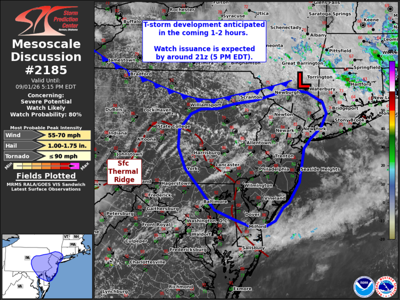
   Mesoscale Discussion 2185
   NWS Storm Prediction Center Norman OK
   0213 PM CDT Tue Sep 01 2026

   Areas affected...portions of the Mid-Atlantic

   Concerning...Severe potential...Watch likely

   Valid 011913Z - 012115Z

   Probability of Watch Issuance...80 percent

   SUMMARY...Thunderstorm development is anticipated within the next
   1-2 hours across portions of the Mid-Atlantic region. Given a
   favorable convective environment, storms will likely intensify and
   pose a severe wind/hail threat through early evening. Watch issuance
   is likely by 21z (5 PM EDT) as thunderstorms begin to mature.

   DISCUSSION...Latest GOES day cloud phase imagery depicts towering
   cumulus on the north/northeastern fringe of a low-level thermal
   ridge (roughly outlined by the 90 F isotherm) where modest warm
   advection is promoting ascent. Some lingering inhibition is noted in
   satellite imagery, but this should continue to erode over the next
   couple of hours as the diurnal heating maximum approaches. Latest
   guidance generally depicts deep convective initiation by 20-21 UTC
   within this regime and potentially along a diffuse frontal boundary
   draped from southern NY into northern PA.

   Regional VWPs continue to sample mid-level flow on the order of 35
   knots, which is supporting similar effective bulk shear values given
   somewhat weak near-surface winds. Based on these observations and
   recent forecast soundings, hodograph elongation appears sufficient
   for organized convection, including the potential for a few
   supercells. While discrete modes persist, large hail (potentially up
   to 1.75 inches) will be possible. A brief tornado may also be
   possible - particularly across northern NJ/far southern NY near a
   weak surface trough where low-level veering may be adequate for a
   localized tornado threat.

   With time, clustering should promote some degree of upscale growth
   with an increasing severe wind threat, especially with southward
   extent into southern NJ and DE where guidance has been consistently
   showing a signal for clustered/linear storm modes. Given the
   favorable convective environment, watch issuance will likely be
   needed as convection begins to intensify.

   ..Moore/Gleason.. 09/01/2026

   ...Please see www.spc.noaa.gov for graphic product...

   ATTN...WFO...OKX...ALY...PHI...BGM...CTP...LWX...

   LAT...LON   39197630 39647672 40027708 40447727 40807724 41137694
               41227667 41247623 41347579 41417522 41627430 41557382
               41367342 41127332 40847347 40637376 40437394 39747407
               39337434 39247450 38977470 38857496 38847534 38987576
               39197630

   MOST PROBABLE PEAK TORNADO INTENSITY...UP TO 90 MPH
   MOST PROBABLE PEAK WIND GUST...55-70 MPH
   MOST PROBABLE PEAK HAIL SIZE...1.00-1.75 IN
|
|
|
Top/All Mesoscale Discussions/Forecast Products/Home |
|