root@sleepynerdlive.com
:
~
$
cat $HOME/public_html/posts/storm-prediction-center-mesoscale-discussion-2180.txt >> story.html | parse_story story.html; rm -f storm-prediction-center-mesoscale-discussion-2180.txt story.html
|
|
| Mesoscale Discussion 2180 | |
|
|
   Mesoscale Discussion 2180
   NWS Storm Prediction Center Norman OK
   1238 PM CDT Mon Aug 31 2026

   Areas affected...Southwest Utah into northwest Arizona and far
   eastern Nevada

   Concerning...Severe potential...Watch unlikely

   Valid 311738Z - 312015Z

   Probability of Watch Issuance...20 percent

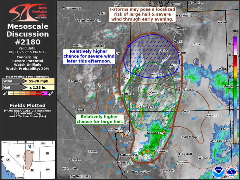
   SUMMARY...Thunderstorms will increase in coverage across portions of
   the Great Basin through early evening, and may pose a localized
   threat of large hail and severe winds. This threat should remain
   sufficiently isolated to preclude watch issuance.

   DISCUSSION...Thunderstorm development is evident across western UT,
   northwest AZ, and far eastern NV based on recent GOES imagery and
   lighting trends. This comes as daytime heating of a seasonally moist
   air mass erodes residual inhibition and ascent ahead of an
   approaching low-amplitude upper wave overspreads the region. Based
   on latest forecast soundings and RAP mesoanalysis estimates, MUCAPE
   values are likely increasing into the 1000-2000 J/kg range through
   the lower CO River Valley under a pocket of colder mid-level
   temperatures. Although buoyancy generally decreases with northward
   extent, a combination of mid-level cold advection and continued
   daytime heating should augment buoyancy region-wide through late
   afternoon and support a steady increase in thunderstorm coverage.

   Recent VWP observations from KICX recently sampled 50-55 knot flow
   near 6 km AGL atop weaker low-level winds. While hodograph structure
   is somewhat poor, sufficient deep-layer wind shear is in place to
   promote organized convection - including a few transient supercells
   - capable of producing large hail. With time, storm mode will likely
   become a modulating factor to large hail production as storm
   coverage increases and clustered modes become more probable.
   However, this may promote cold pool consolidation through late
   afternoon when low-level lapse rates will be maximized.
   Consequently, the potential for severe wind gusts may increase
   through late afternoon/early evening as convection spreads
   north/northeast across western UT.

   Regardless, latest time-lagged CAM ensembles appear to be capturing
   recent convection trends will and generally suggest that the overall
   severe hail/wind threat should remain too widely spaced/isolated to
   warrant watch issuance.

   ..Moore/Gleason.. 08/31/2026

   ...Please see www.spc.noaa.gov for graphic product...

   ATTN...WFO...FGZ...SLC...VEF...LKN...

   LAT...LON   35861380 36261388 36841410 37591451 38021462 38721461
               39721416 40071351 40161283 39931211 39521161 39181137
               38481138 37751144 37261159 36751179 36081197 35151259
               34941296 34931346 34931368 35031387 35181400 35481397
               35861380

   MOST PROBABLE PEAK WIND GUST...55-70 MPH
   MOST PROBABLE PEAK HAIL SIZE...UP TO 1.25 IN
|
|
|
Top/All Mesoscale Discussions/Forecast Products/Home |
|