root@sleepynerdlive.com
:
~
$
cat $HOME/public_html/posts/storm-prediction-center-mesoscale-discussion-2176.txt >> story.html | parse_story story.html; rm -f storm-prediction-center-mesoscale-discussion-2176.txt story.html
|
|
| Mesoscale Discussion 2176 | |
|
|
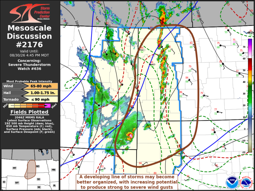
Mesoscale Discussion 2176 NWS Storm Prediction Center Norman OK 0349 PM CDT Sun Aug 30 2026 Areas affected...western North Dakota...northwestern South Dakota...adjacent portions of southeastern Montana and northeastern Wyoming Concerning...Severe Thunderstorm Watch 636... Valid 302049Z - 302245Z The severe weather threat for Severe Thunderstorm Watch 636 continues. SUMMARY...A developing line of thunderstorms across western North Dakota may begin to become better organized with increasing potential to produce strong to severe wind gusts while approaching the Minot through Bismarck ND and Mobridge SD vicinity through 5-7 PM CDT (4-6 PM MDT). Trends will continue to be monitored for the possibility of a downstream severe weather watch. DISCUSSION...A surface cold front, enhanced by convective outflow, continues to strengthen while advancing east-southeastward into and across the Montana/western Dakotas state border vicinity, with 2-hourly surface pressure rises on the order of 2-3+ mb evident in 20Z surface observations across a broad area of eastern Montana into the lee of the Bighorn Mountains. A downstream surface pressure fall center appears to be developing near/southwest through west of the Bismarck into Minot ND vicinity, ahead of increasing thunderstorm development within the moderately unstable boundary-layer near the pre-frontal surface trough axis. Thunderstorm initiation across western North Dakota has been aided by eroding inhibition, in the presence of continuing insolation and the onset of weak cooling aloft. As the leading edge of lower-level cooling continues to overtake the surface trough, initially discrete storm development may quickly grow upscale into at least a narrow evolving line. Although shear is initially modest, with further strengthening, convection probably will better organize, accompanied by evolving lower/mid-tropospheric meso-beta scale cyclonic circulations with increasing potential to produce strong to severe surface gusts. ..Kerr.. 08/30/2026 ...Please see www.spc.noaa.gov for graphic product... ATTN...WFO...ABR...BIS...UNR...BYZ...GGW... LAT...LON 49070279 48660132 45740124 44880222 44430405 45050505 46370444 47250416 47980416 48760357 49070279 MOST PROBABLE PEAK TORNADO INTENSITY...UP TO 90 MPH MOST PROBABLE PEAK WIND GUST...65-80 MPH MOST PROBABLE PEAK HAIL SIZE...1.00-1.75 IN |
|
|
Top/All Mesoscale Discussions/Forecast Products/Home |
|