root@sleepynerdlive.com
:
~
$
cat $HOME/public_html/posts/storm-prediction-center-mesoscale-discussion-2171.txt >> story.html | parse_story story.html; rm -f storm-prediction-center-mesoscale-discussion-2171.txt story.html
|
|
| Mesoscale Discussion 2171 | |
|
|
   Mesoscale Discussion 2171
   NWS Storm Prediction Center Norman OK
   0608 PM CDT Sat Aug 29 2026

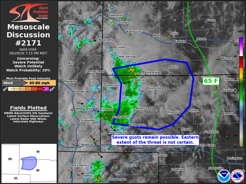
   Areas affected...Western into central Nebraska and southwestern
   South Dakota

   Concerning...Severe potential...Watch unlikely

   Valid 292308Z - 300115Z

   Probability of Watch Issuance...20 percent

   SUMMARY...A line of loosely organized thunderstorms has produced
   several severe gusts over the past couple of hours. Recent
   radar/lightning trends have shown some weakening, though a few
   severe gusts remain possible into early evening. A watch is not
   currently expected.

   DISCUSSION...A line of thunderstorms, with only isolated deeper
   convective cores, has continued to produce severe wind gusts in the
   55-75 mph range over the past couple of hours. As this line
   continues east this evening, it will encounter a drier pocket of air
   where dewpoints have been mixing out late this afternoon. Farther
   east, in central Nebraska/South Dakota, dewpoints are in the
   mid/upper 60s F. MRMS CAPPI data suggests the strongest cores are
   losing definition as they encounter weaker buoyancy/greater MLCIN.
   Though a modest increase in the low-level jet will occur this
   evening, it is unclear if these storms will maintain organization
   more than an hour or two given otherwise poor synoptic support. A
   few severe wind gusts are possible with this activity.

   ..Wendt/Guyer.. 08/29/2026

   ...Please see www.spc.noaa.gov for graphic product...

   ATTN...WFO...LBF...UNR...CYS...

   LAT...LON   41740363 41830358 42120342 42790335 43170366 43420180
               43320105 42930082 42200096 41740154 41600205 41740363

   MOST PROBABLE PEAK WIND GUST...65-80 MPH
|
|
|
Top/All Mesoscale Discussions/Forecast Products/Home |
|