root@sleepynerdlive.com
:
~
$
cat $HOME/public_html/posts/storm-prediction-center-mesoscale-discussion-2143.txt >> story.html | parse_story story.html; rm -f storm-prediction-center-mesoscale-discussion-2143.txt story.html
|
|
| Mesoscale Discussion 2143 | |
|
|
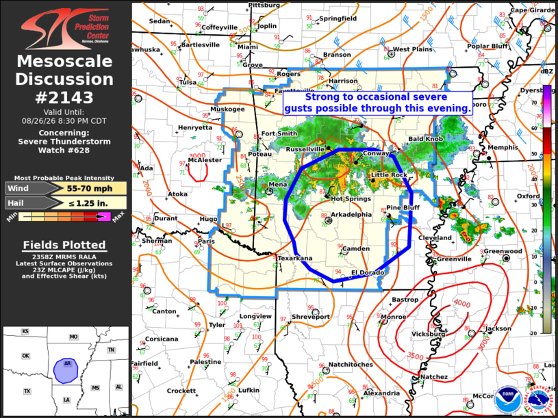
Mesoscale Discussion 2143 NWS Storm Prediction Center Norman OK 0701 PM CDT Wed Aug 26 2026 Areas affected...portions of central and southern Arkansas Concerning...Severe Thunderstorm Watch 628... Valid 270001Z - 270130Z The severe weather threat for Severe Thunderstorm Watch 628 continues. SUMMARY...A cluster of storms over central AR should continue to move south with occasional strong/severe gusts possible through this evening. DISCUSSION...Across WW628, radar imagery showed a cluster of strong to severe thunderstorms from southeastern OK into central AR. The strongest storms within the cluster are located across central AR, and this local clustering should continue this evening with several observed outflows likely to merge over the next hour or so. With plentiful buoyancy in place, maintenance of the ongoing storms or new development on the outflow appears likely. Modest deep-layer shear (15-25 kt) is supportive of a pulse multicell storm mode. This may allow for occasional strong to severe gusts given the favorable environment for strong downdrafts with high PWATs and consolidated outflow. Radar trends and short term model guidance show these storms continuing to propagate south/southeast into southern AR with a continued severe risk across central and southern portions of WW628 this evening. ..Lyons.. 08/27/2026 ...Please see www.spc.noaa.gov for graphic product... ATTN...WFO...LZK...SHV... LAT...LON 33329341 33589367 33759372 34109389 34429387 34919359 35229288 35219220 35119183 34539148 33679154 33269220 33139296 33329341 MOST PROBABLE PEAK WIND GUST...55-70 MPH MOST PROBABLE PEAK HAIL SIZE...UP TO 1.25 IN |
|
|
Top/All Mesoscale Discussions/Forecast Products/Home |
|