|
|
| Mesoscale Discussion 1058 | |
| Next MD > | |
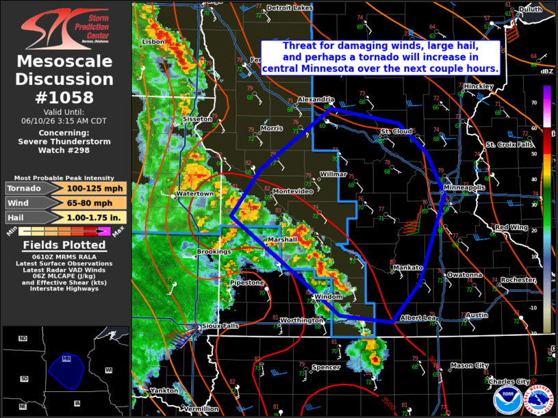 | |
Mesoscale Discussion 1058 NWS Storm Prediction Center Norman OK 0112 AM CDT Wed Jun 10 2026 Areas affected...Portions of southern and central Minnesota Concerning...Severe Thunderstorm Watch 298... Valid 100612Z - 100815Z The severe weather threat for Severe Thunderstorm Watch 298 continues. SUMMARY...Damaging winds, large hail, and a conditional tornado threat will exist with storms moving into central Minnesota tonight. Local extensions of WW 298 and/or a new watch may be needed. DISCUSSION...Storms in southwest Minnesota are expected to continue moving northeastward tonight. Moderate to strong buoyancy and effective shear of 30-35 kt will support a threat for damaging winds and large hail with the strongest storms. The KMPX VAD does show enlarged hodographs. A tornado would be conditionally possible in this environment. That said, the low-level thermodynamic environment is only marginally favorable tonight given the presence of at least modest MLCIN. How far east the strongest activity will reach is also a question as the environment becomes less favorable near the Mississippi River. Local extensions of WW 298 and/or a new watch may be needed as storms develop northeastward. ..Wendt.. 06/10/2026 ...Please see www.spc.noaa.gov for graphic product... ATTN...WFO...MPX...FSD... LAT...LON 43649399 43719474 44139535 44739630 45209588 45849486 45699388 45389348 44949322 44049359 43649399 MOST PROBABLE PEAK TORNADO INTENSITY...100-125 MPH MOST PROBABLE PEAK WIND GUST...65-80 MPH MOST PROBABLE PEAK HAIL SIZE...1.00-1.75 IN | |
| Top/All Mesoscale Discussions/Forecast Products/Home | |