root@sleepynerdlive.com
:
~
$
su - sleepynerd && cat $HOME/public_html/posts/spc-md-931.txt | parse_content --format=auto
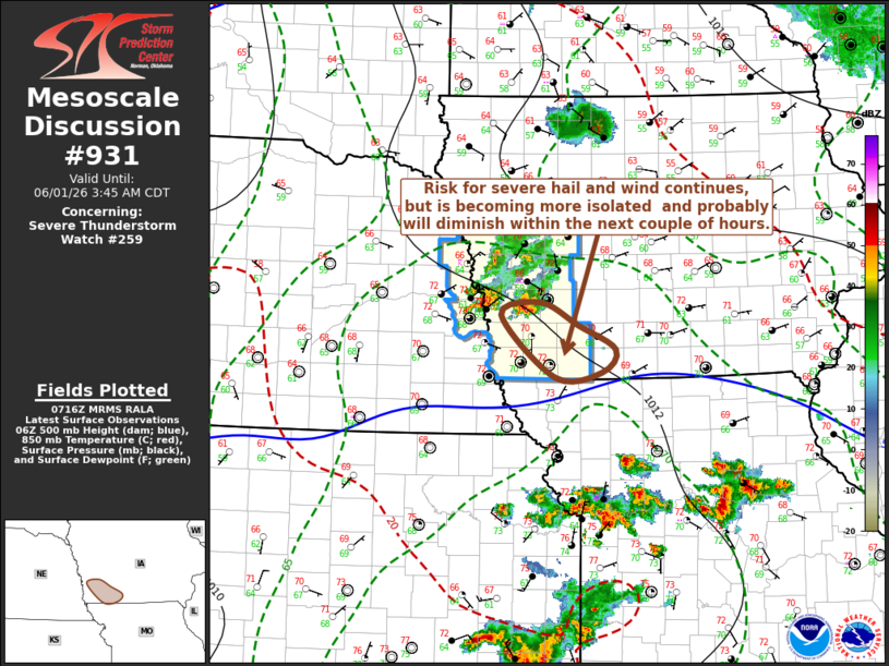
MD 0931 CONCERNING SEVERE THUNDERSTORM WATCH 259… FOR PARTS OF SOUTHWESTERN IOWA
Mesoscale Discussion 0931
NWS Storm Prediction Center Norman OK
0218 AM CDT Mon Jun 01 2026

Areas affected...parts of southwestern Iowa

Concerning...Severe Thunderstorm Watch 259...

Valid 010718Z - 010845Z

The severe weather threat for Severe Thunderstorm Watch 259
continues.

SUMMARY...Isolated strong thunderstorm development posing a risk for
severe hail and locally strong surface gusts remains possible,
perhaps another few hours in a corridor southeast of Omaha through
the Lamoni IA vicinity.  However, this threat appears isolated and
marginal enough that a new severe weather watch is not currently
anticipated.

DISCUSSION...Stronger thunderstorm development has become more
isolated and now focused to the east-southeast of Omaha, where
latest objective analysis indicates boundary-layer instability
remains maximized in a narrow corridor extending southeastward
toward the Lamoni, IA vicinity.  Given potential inflow of this air,
continuing isolated supercell development remains possible.  How
much longer, however, remains unclear due to weak supporting
low-level forcing for ascent and increasing inhibition with
continued slow boundary-layer cooling.

..Kerr.. 06/01/2026

...Please see www.spc.noaa.gov for graphic product...

ATTN...WFO...DMX...OAX...

LAT...LON   41379514 41139462 40879412 40639430 40589495 41249568
            41379514