root@sleepynerdlive.com
:
~
$
su - sleepynerd && cat $HOME/public_html/posts/spc-md-480.txt | parse_content --format=auto
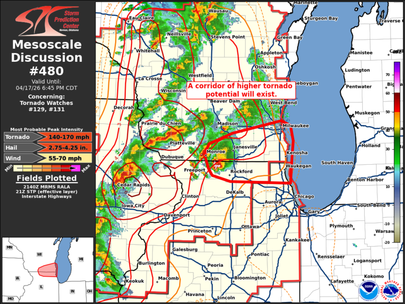
MD 0480 CONCERNING TORNADO WATCH 129…131… FOR SOUTHERN WISCONSIN AND FAR NORTHERN ILLINOIS
Mesoscale Discussion 0480
NWS Storm Prediction Center Norman OK
0442 PM CDT Fri Apr 17 2026

Areas affected...Southern Wisconsin and far northern Illinois

Concerning...Tornado Watch 129...131...

Valid 172142Z - 172345Z

The severe weather threat for Tornado Watch 129, 131 continues.

SUMMARY...Leading supercells across northern Illinois and southern
Wisconsin will likely pose a tornado (possibly significant) and very
large hail threat as they move downstream over the next 1-2 hours.

DISCUSSION...A pair of leading supercells continues to precede a
broken line of storms along the IL/WI border. Regional radar imagery
continues to indicate that these cells are rather intense with a
three-body scatter spike, a bounded weak echo region, and a recent
3-inch hail report noted with the southern storm. An improving
downstream convective environment is noted in recent observations
and analyses (0-1 km SRH values remain between 200-250 m2/s2 per the
KMKX VWP, and STP values have recently increased to 2-3 per recent
mesoanalysis). Additionally, the southern storm will also likely
propagate along a subtle surface theta-e gradient draped across
northern IL to southern WI. Given these trends and the presence of a
well-established updraft/mesocyclone with the southern cell, the
potential for very large hail (likely in excess of 2 inches) and
strong tornadoes will likely persist for the next couple of hours
downstream into southeast WI and far northern IL.

..Moore.. 04/17/2026

...Please see www.spc.noaa.gov for graphic product...

ATTN...WFO...LOT...MKX...DVN...

LAT...LON   42138771 42158906 42268948 42378957 42608965 42798955
            42968903 43188791 43108770 42848764 42588767 42138771

MOST PROBABLE PEAK TORNADO INTENSITY...140-170 MPH
MOST PROBABLE PEAK WIND GUST...55-70 MPH
MOST PROBABLE PEAK HAIL SIZE...2.75-4.25 IN