Note:
The expiration time in the watch graphic is amended if the watch is
replaced, cancelled or extended.
Note: Click for Watch Status Reports.
SEL8
URGENT - IMMEDIATE BROADCAST REQUESTED
Tornado Watch Number 68
NWS Storm Prediction Center Norman OK
1130 AM EDT Mon Mar 16 2026
The NWS Storm Prediction Center has issued a
* Tornado Watch for portions of
Delaware
Eastern Maryland
New Jersey
Southeast Pennsylvania
Coastal Waters
* Effective this Monday morning and evening from 1130 AM until
700 PM EDT.
* Primary threats include...
A few tornadoes likely with a couple intense tornadoes possible
Widespread damaging winds and isolated significant gusts to 80
mph likely
Isolated large hail events to 1 inch in diameter possible
SUMMARY...Pre-frontal bands of storms will spread northeastward from
Virginia into southeast Pennsylvania through the afternoon, with an
attendant threat for swaths of damaging winds (60-80 mph) and a few
tornadoes with embedded circulations. A couple of strong tornadoes
(EF2) will be possible.
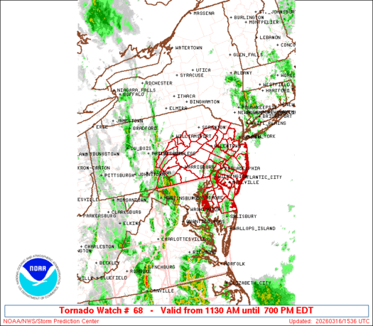
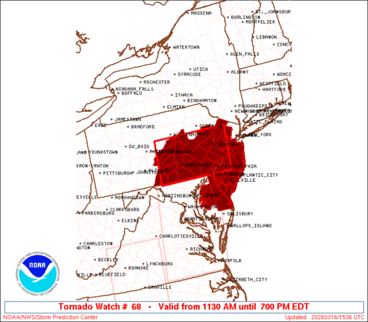
The tornado watch area is approximately along and 80 statute miles
east and west of a line from 50 miles northwest of Allentown PA to
35 miles west of Wilmington DE. For a complete depiction of the
watch see the associated watch outline update (WOUS64 KWNS WOU8).
PRECAUTIONARY/PREPAREDNESS ACTIONS...
REMEMBER...A Tornado Watch means conditions are favorable for
tornadoes and severe thunderstorms in and close to the watch
area. Persons in these areas should be on the lookout for
threatening weather conditions and listen for later statements
and possible warnings.
&&
OTHER WATCH INFORMATION...CONTINUE...WW 65...WW 66...WW 67...
AVIATION...Tornadoes and a few severe thunderstorms with hail
surface and aloft to 1 inch. Extreme turbulence and surface wind
gusts to 70 knots. A few cumulonimbi with maximum tops to 450. Mean
storm motion vector 22045.
...Thompson
   SEL8

   URGENT - IMMEDIATE BROADCAST REQUESTED
   Tornado Watch Number 68
   NWS Storm Prediction Center Norman OK
   1130 AM EDT Mon Mar 16 2026

   The NWS Storm Prediction Center has issued a

   * Tornado Watch for portions of
     Delaware
     Eastern Maryland
     New Jersey
     Southeast Pennsylvania
     Coastal Waters

   * Effective this Monday morning and evening from 1130 AM until
     700 PM EDT.

   * Primary threats include...
     A few tornadoes likely with a couple intense tornadoes possible
     Widespread damaging winds and isolated significant gusts to 80
       mph likely
     Isolated large hail events to 1 inch in diameter possible

   SUMMARY...Pre-frontal bands of storms will spread northeastward from
   Virginia into southeast Pennsylvania through the afternoon, with an
   attendant threat for swaths of damaging winds (60-80 mph) and a few
   tornadoes with embedded circulations.  A couple of strong tornadoes
   (EF2) will be possible.

   The tornado watch area is approximately along and 80 statute miles
   east and west of a line from 50 miles northwest of Allentown PA to
   35 miles west of Wilmington DE. For a complete depiction of the
   watch see the associated watch outline update (WOUS64 KWNS WOU8).

   PRECAUTIONARY/PREPAREDNESS ACTIONS...

   REMEMBER...A Tornado Watch means conditions are favorable for
   tornadoes and severe thunderstorms in and close to the watch
   area. Persons in these areas should be on the lookout for
   threatening weather conditions and listen for later statements
   and possible warnings.

   &&

   OTHER WATCH INFORMATION...CONTINUE...WW 65...WW 66...WW 67...

   AVIATION...Tornadoes and a few severe thunderstorms with hail
   surface and aloft to 1 inch. Extreme turbulence and surface wind
   gusts to 70 knots. A few cumulonimbi with maximum tops to 450. Mean
   storm motion vector 22045.

   ...Thompson
Note:
The Aviation Watch (SAW) product is an approximation to the watch area.
The actual watch is depicted by the shaded areas.
   SAW8
   WW 68 TORNADO DE MD NJ PA CW 161530Z - 162300Z
   AXIS..80 STATUTE MILES EAST AND WEST OF LINE..
   50NW ABE/ALLENTOWN PA/ - 35W ILG/WILMINGTON DE/
   ..AVIATION COORDS.. 70NM E/W /40NNW ETX - 36ENE EMI/
   HAIL SURFACE AND ALOFT..1 INCH. WIND GUSTS..70 KNOTS.
   MAX TOPS TO 450. MEAN STORM MOTION VECTOR 22045.

   LAT...LON 41157457 39667474 39667775 41157765

   THIS IS AN APPROXIMATION TO THE WATCH AREA.  FOR A
   COMPLETE DEPICTION OF THE WATCH SEE WOUS64 KWNS
   FOR WOU8.
Watch 68 Status Report Messages:
STATUS REPORT #4 ON WW 68

VALID 162040Z - 162140Z

SEVERE WEATHER THREAT CONTINUES RIGHT OF A LINE FROM 30 NE BWI TO
30 NW ILG TO 20 W ABE TO 10 NW AVP.

..BENTLEY..03/16/26

ATTN...WFO...PHI...CTP...

&&

STATUS REPORT FOR WT 68

SEVERE WEATHER THREAT CONTINUES FOR THE FOLLOWING AREAS

DEC001-003-005-162140-

DE
.    DELAWARE COUNTIES INCLUDED ARE

KENT     NEW CASTLE  SUSSEX
$$


MDC011-029-035-041-162140-

MD
.    MARYLAND COUNTIES INCLUDED ARE

CAROLINE     KENT QUEEN ANNE'S
TALBOT
$$


NJC001-005-007-009-011-015-019-021-023-025-027-029-033-035-037-
041-162140-

NJ
.    NEW JERSEY COUNTIES INCLUDED ARE

ATLANTIC     BURLINGTON  CAMDEN
CAPE MAY     CUMBERLAND  GLOUCESTER
HUNTERDON     MERCER MIDDLESEX
MONMOUTH     MORRIS OCEAN
SALEM     SOMERSET SUSSEX
WARREN
$$


PAC011-017-025-029-045-077-089-091-095-101-162140-

PA
.    PENNSYLVANIA COUNTIES INCLUDED ARE

BERKS     BUCKS CARBON
CHESTER      DELAWARE LEHIGH
MONROE     MONTGOMERY  NORTHAMPTON
PHILADELPHIA
$$


ANZ430-431-162140-

CW

.    ADJACENT COASTAL WATERS INCLUDED ARE

DELAWARE BAY WATERS NORTH OF EAST POINT NJ TO SLAUGHTER BEACH DE

DELAWARE BAY WATERS SOUTH OF EAST POINT NJ TO SLAUGHTER BEACH DE

$$
THE WATCH STATUS MESSAGE IS FOR GUIDANCE PURPOSES ONLY.  PLEASE
REFER TO WATCH COUNTY NOTIFICATION STATEMENTS FOR OFFICIAL
INFORMATION ON COUNTIES...INDEPENDENT CITIES AND MARINE ZONES
CLEARED FROM SEVERE THUNDERSTORM AND TORNADO WATCHES.
$$

STATUS REPORT #3 ON WW 68

VALID 161920Z - 162040Z

SEVERE WEATHER THREAT CONTINUES RIGHT OF A LINE FROM 30 N BWI TO
20 SE CXY TO 25 ENE CXY TO 45 NE CXY TO 10 NW AVP.

..BENTLEY..03/16/26

ATTN...WFO...PHI...CTP...

&&

STATUS REPORT FOR WT 68

SEVERE WEATHER THREAT CONTINUES FOR THE FOLLOWING AREAS

DEC001-003-005-162040-

DE
.    DELAWARE COUNTIES INCLUDED ARE

KENT     NEW CASTLE  SUSSEX
$$


MDC011-029-035-041-162040-

MD
.    MARYLAND COUNTIES INCLUDED ARE

CAROLINE     KENT QUEEN ANNE'S
TALBOT
$$


NJC001-005-007-009-011-015-019-021-023-025-027-029-033-035-037-
041-162040-

NJ
.    NEW JERSEY COUNTIES INCLUDED ARE

ATLANTIC     BURLINGTON  CAMDEN
CAPE MAY     CUMBERLAND  GLOUCESTER
HUNTERDON     MERCER MIDDLESEX
MONMOUTH     MORRIS OCEAN
SALEM     SOMERSET SUSSEX
WARREN
$$


PAC011-017-025-029-045-071-075-077-089-091-095-101-107-133-
162040-

PA
.    PENNSYLVANIA COUNTIES INCLUDED ARE

BERKS     BUCKS CARBON
CHESTER      DELAWARE LANCASTER
LEBANON      LEHIGH MONROE
MONTGOMERY     NORTHAMPTON PHILADELPHIA
SCHUYLKILL     YORK
$$


ANZ430-431-162040-

CW

.    ADJACENT COASTAL WATERS INCLUDED ARE

DELAWARE BAY WATERS NORTH OF EAST POINT NJ TO SLAUGHTER BEACH DE

DELAWARE BAY WATERS SOUTH OF EAST POINT NJ TO SLAUGHTER BEACH DE

$$
THE WATCH STATUS MESSAGE IS FOR GUIDANCE PURPOSES ONLY.  PLEASE
REFER TO WATCH COUNTY NOTIFICATION STATEMENTS FOR OFFICIAL
INFORMATION ON COUNTIES...INDEPENDENT CITIES AND MARINE ZONES
CLEARED FROM SEVERE THUNDERSTORM AND TORNADO WATCHES.
$$

STATUS REPORT #2 ON WW 68

VALID 161810Z - 161940Z

SEVERE WEATHER THREAT CONTINUES RIGHT OF A LINE FROM 5 NNE HGR TO
25 WSW CXY TO 35 SSW IPT TO 10 NW IPT.

..LYONS..03/16/26

ATTN...WFO...PHI...CTP...

&&

STATUS REPORT FOR WT 68

SEVERE WEATHER THREAT CONTINUES FOR THE FOLLOWING AREAS

DEC001-003-005-161940-

DE
.    DELAWARE COUNTIES INCLUDED ARE

KENT     NEW CASTLE  SUSSEX
$$


MDC011-029-035-041-161940-

MD
.    MARYLAND COUNTIES INCLUDED ARE

CAROLINE     KENT QUEEN ANNE'S
TALBOT
$$


NJC001-005-007-009-011-015-019-021-023-025-027-029-033-035-037-
041-161940-

NJ
.    NEW JERSEY COUNTIES INCLUDED ARE

ATLANTIC     BURLINGTON  CAMDEN
CAPE MAY     CUMBERLAND  GLOUCESTER
HUNTERDON     MERCER MIDDLESEX
MONMOUTH     MORRIS OCEAN
SALEM     SOMERSET SUSSEX
WARREN
$$


PAC001-011-017-025-029-037-041-043-045-071-075-077-089-091-093-
095-097-099-101-107-109-119-133-161940-

PA
.    PENNSYLVANIA COUNTIES INCLUDED ARE

ADAMS     BERKS BUCKS
CARBON     CHESTER COLUMBIA
CUMBERLAND     DAUPHIN DELAWARE
LANCASTER     LEBANON LEHIGH
MONROE     MONTGOMERY  MONTOUR
NORTHAMPTON     NORTHUMBERLAND PERRY
PHILADELPHIA     SCHUYLKILL  SNYDER
UNION     YORK
$$


ANZ430-431-161940-

CW

.    ADJACENT COASTAL WATERS INCLUDED ARE

DELAWARE BAY WATERS NORTH OF EAST POINT NJ TO SLAUGHTER BEACH DE

DELAWARE BAY WATERS SOUTH OF EAST POINT NJ TO SLAUGHTER BEACH DE

$$
THE WATCH STATUS MESSAGE IS FOR GUIDANCE PURPOSES ONLY.  PLEASE
REFER TO WATCH COUNTY NOTIFICATION STATEMENTS FOR OFFICIAL
INFORMATION ON COUNTIES...INDEPENDENT CITIES AND MARINE ZONES
CLEARED FROM SEVERE THUNDERSTORM AND TORNADO WATCHES.
$$

STATUS REPORT #1 ON WW 68

VALID 161620Z - 161740Z

THE SEVERE WEATHER THREAT CONTINUES ACROSS THE ENTIRE WATCH AREA.

..LYONS..03/16/26

ATTN...WFO...PHI...CTP...

&&

STATUS REPORT FOR WT 68

SEVERE WEATHER THREAT CONTINUES FOR THE FOLLOWING AREAS

DEC001-003-005-161740-

DE
.    DELAWARE COUNTIES INCLUDED ARE

KENT     NEW CASTLE  SUSSEX
$$


MDC011-029-035-041-161740-

MD
.    MARYLAND COUNTIES INCLUDED ARE

CAROLINE     KENT QUEEN ANNE'S
TALBOT
$$


NJC001-005-007-009-011-015-019-021-023-025-027-029-033-035-037-
041-161740-

NJ
.    NEW JERSEY COUNTIES INCLUDED ARE

ATLANTIC     BURLINGTON  CAMDEN
CAPE MAY     CUMBERLAND  GLOUCESTER
HUNTERDON     MERCER MIDDLESEX
MONMOUTH     MORRIS OCEAN
SALEM     SOMERSET SUSSEX
WARREN
$$


PAC001-011-017-025-029-037-041-043-045-055-067-071-075-077-087-
089-091-093-095-097-099-101-107-109-119-133-161740-

PA
.    PENNSYLVANIA COUNTIES INCLUDED ARE

ADAMS     BERKS BUCKS
CARBON     CHESTER COLUMBIA
CUMBERLAND     DAUPHIN DELAWARE
FRANKLIN     JUNIATA LANCASTER
LEBANON      LEHIGH MIFFLIN
MONROE     MONTGOMERY  MONTOUR
NORTHAMPTON     NORTHUMBERLAND PERRY
PHILADELPHIA     SCHUYLKILL  SNYDER
UNION     YORK
$$


ANZ430-431-161740-

CW

.    ADJACENT COASTAL WATERS INCLUDED ARE

DELAWARE BAY WATERS NORTH OF EAST POINT NJ TO SLAUGHTER BEACH DE

DELAWARE BAY WATERS SOUTH OF EAST POINT NJ TO SLAUGHTER BEACH DE

$$
THE WATCH STATUS MESSAGE IS FOR GUIDANCE PURPOSES ONLY.  PLEASE
REFER TO WATCH COUNTY NOTIFICATION STATEMENTS FOR OFFICIAL
INFORMATION ON COUNTIES...INDEPENDENT CITIES AND MARINE ZONES
CLEARED FROM SEVERE THUNDERSTORM AND TORNADO WATCHES.
$$
Note:
Click for Complete Product Text.
Tornadoes
| Probability of 2 or more tornadoes | Mod (60%) |
| Probability of 1 or more strong (EF2-EF5) tornadoes | Mod (30%) |
Wind
| Probability of 10 or more severe wind events | High (80%) |
| Probability of 1 or more wind events > 65 knots | High (70%) |
Hail
| Probability of 10 or more severe hail events | Low (20%) |
| Probability of 1 or more hailstones > 2 inches | Low (10%) |
Combined Severe Hail/Wind
| Probability of 6 or more combined severe hail/wind events | High (>95%) |
For each watch, probabilities for particular events inside the watch
(listed above in each table) are determined by the issuing forecaster.
The “Low” category contains probability values ranging from less than 2%
to 20% (EF2-EF5 tornadoes), less than 5% to 20% (all other probabilities),
“Moderate” from 30% to 60%, and “High” from 70% to greater than 95%.
High values are bolded and lighter in color to provide awareness of
an increased threat for a particular event.
Source link


