Note:
The expiration time in the watch graphic is amended if the watch is
replaced, cancelled or extended.
Note: Click for Watch Status Reports.
SEL1
URGENT - IMMEDIATE BROADCAST REQUESTED
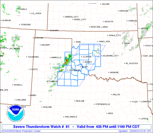
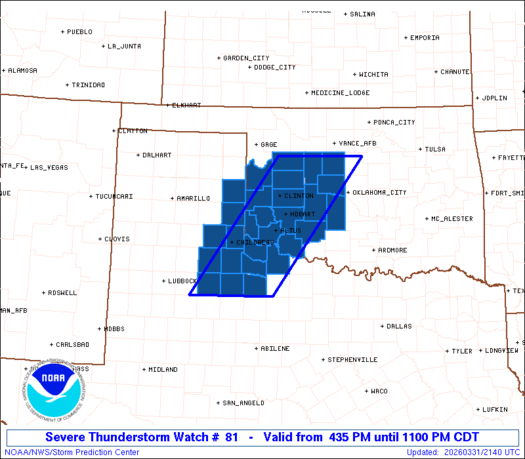
Severe Thunderstorm Watch Number 81
NWS Storm Prediction Center Norman OK
435 PM CDT Tue Mar 31 2026
The NWS Storm Prediction Center has issued a
* Severe Thunderstorm Watch for portions of
Western Oklahoma
Western North Texas and Panhandle
* Effective this Tuesday afternoon and evening from 435 PM until
1100 PM CDT.
* Primary threats include...
Scattered damaging wind gusts to 70 mph possible
Scattered large hail events to 1.5 inches in diameter possible
A tornado or two possible
SUMMARY...Storms are expected to further develop and intensify
through early evening across the southeast Texas Panhandle/Low
Rolling Plains into western Oklahoma, with large hail and locally
damaging winds as the primary hazards.
The severe thunderstorm watch area is approximately along and 55
statute miles east and west of a line from 75 miles northeast of
Clinton OK to 70 miles south of Childress TX. For a complete
depiction of the watch see the associated watch outline update
(WOUS64 KWNS WOU1).
PRECAUTIONARY/PREPAREDNESS ACTIONS...
REMEMBER...A Severe Thunderstorm Watch means conditions are
favorable for severe thunderstorms in and close to the watch area.
Persons in these areas should be on the lookout for threatening
weather conditions and listen for later statements and possible
warnings. Severe thunderstorms can and occasionally do produce
tornadoes.
&&
OTHER WATCH INFORMATION...CONTINUE...WW 79...WW 80...
AVIATION...A few severe thunderstorms with hail surface and aloft to
1.5 inches. Extreme turbulence and surface wind gusts to 60 knots. A
few cumulonimbi with maximum tops to 500. Mean storm motion vector
26025.
...Guyer
   SEL1

   URGENT - IMMEDIATE BROADCAST REQUESTED
   Severe Thunderstorm Watch Number 81
   NWS Storm Prediction Center Norman OK
   435 PM CDT Tue Mar 31 2026

   The NWS Storm Prediction Center has issued a

   * Severe Thunderstorm Watch for portions of
     Western Oklahoma
     Western North Texas and Panhandle

   * Effective this Tuesday afternoon and evening from 435 PM until
     1100 PM CDT.

   * Primary threats include...
     Scattered damaging wind gusts to 70 mph possible
     Scattered large hail events to 1.5 inches in diameter possible
     A tornado or two possible

   SUMMARY...Storms are expected to further develop and intensify
   through early evening across the southeast Texas Panhandle/Low
   Rolling Plains into western Oklahoma, with large hail and locally
   damaging winds as the primary hazards.

   The severe thunderstorm watch area is approximately along and 55
   statute miles east and west of a line from 75 miles northeast of
   Clinton OK to 70 miles south of Childress TX. For a complete
   depiction of the watch see the associated watch outline update
   (WOUS64 KWNS WOU1).

   PRECAUTIONARY/PREPAREDNESS ACTIONS...

   REMEMBER...A Severe Thunderstorm Watch means conditions are
   favorable for severe thunderstorms in and close to the watch area.
   Persons in these areas should be on the lookout for threatening
   weather conditions and listen for later statements and possible
   warnings. Severe thunderstorms can and occasionally do produce
   tornadoes.

   &&

   OTHER WATCH INFORMATION...CONTINUE...WW 79...WW 80...

   AVIATION...A few severe thunderstorms with hail surface and aloft to
   1.5 inches. Extreme turbulence and surface wind gusts to 60 knots. A
   few cumulonimbi with maximum tops to 500. Mean storm motion vector
   26025.

   ...Guyer
Note:
The Aviation Watch (SAW) product is an approximation to the watch area.
The actual watch is depicted by the shaded areas.
   SAW1
   WW 81 SEVERE TSTM OK TX 312135Z - 010400Z
   AXIS..55 STATUTE MILES EAST AND WEST OF LINE..
   75NE CSM/CLINTON OK/ - 70S CDS/CHILDRESS TX/
   ..AVIATION COORDS.. 50NM E/W /22SW END - 57S CDS/
   HAIL SURFACE AND ALOFT..1.5 INCHES. WIND GUSTS..60 KNOTS.
   MAX TOPS TO 500. MEAN STORM MOTION VECTOR 26025.

   LAT...LON 36099727 33419933 33410123 36099924

   THIS IS AN APPROXIMATION TO THE WATCH AREA.  FOR A
   COMPLETE DEPICTION OF THE WATCH SEE WOUS64 KWNS
   FOR WOU1.
Watch 81 Status Report Messages:
STATUS REPORT #1 ON WW 81

VALID 312300Z - 010040Z

THE SEVERE WEATHER THREAT CONTINUES ACROSS THE ENTIRE WATCH AREA.

FOR ADDITIONAL INFORMATION SEE MESOSCALE DISCUSSION 312

..SQUITIERI..03/31/26

ATTN...WFO...OUN...LUB...AMA...

&&

STATUS REPORT FOR WS 81

SEVERE WEATHER THREAT CONTINUES FOR THE FOLLOWING AREAS

OKC009-011-015-017-031-039-043-051-055-057-065-073-075-141-149-
010040-

OK
.    OKLAHOMA COUNTIES INCLUDED ARE

BECKHAM      BLAINE CADDO
CANADIAN     COMANCHE CUSTER
DEWEY     GRADY GREER
HARMON     JACKSON KINGFISHER
KIOWA     TILLMAN WASHITA
$$


TXC075-087-101-125-155-197-269-275-345-487-010040-

TX
.    TEXAS COUNTIES INCLUDED ARE

CHILDRESS     COLLINGSWORTH COTTLE
DICKENS      FOARD HARDEMAN
KING     KNOX MOTLEY
WILBARGER
$$


THE WATCH STATUS MESSAGE IS FOR GUIDANCE PURPOSES ONLY.  PLEASE
REFER TO WATCH COUNTY NOTIFICATION STATEMENTS FOR OFFICIAL
INFORMATION ON COUNTIES...INDEPENDENT CITIES AND MARINE ZONES
CLEARED FROM SEVERE THUNDERSTORM AND TORNADO WATCHES.
$$
Note:
Click for Complete Product Text.
Tornadoes
| Probability of 2 or more tornadoes | Low (20%) |
| Probability of 1 or more strong (EF2-EF5) tornadoes | Low (
|
Wind
| Probability of 10 or more severe wind events | Mod (50%) |
| Probability of 1 or more wind events > 65 knots | Low (20%) |
Hail
| Probability of 10 or more severe hail events | Mod (50%) |
| Probability of 1 or more hailstones > 2 inches | Low (20%) |
Combined Severe Hail/Wind
| Probability of 6 or more combined severe hail/wind events | High (80%) |
For each watch, probabilities for particular events inside the watch
(listed above in each table) are determined by the issuing forecaster.
The “Low” category contains probability values ranging from less than 2%
to 20% (EF2-EF5 tornadoes), less than 5% to 20% (all other probabilities),
“Moderate” from 30% to 60%, and “High” from 70% to greater than 95%.
High values are bolded and lighter in color to provide awareness of
an increased threat for a particular event.
Source link


