Note:
The expiration time in the watch graphic is amended if the watch is
replaced, cancelled or extended.
Note: Click for Watch Status Reports.
SEL6
URGENT - IMMEDIATE BROADCAST REQUESTED
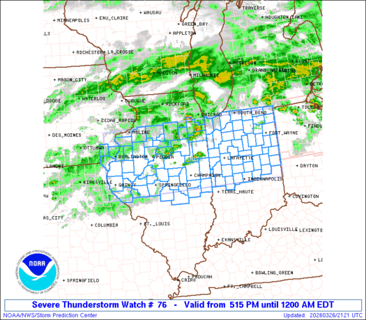
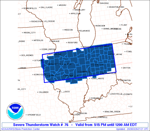
Severe Thunderstorm Watch Number 76
NWS Storm Prediction Center Norman OK
515 PM EDT Thu Mar 26 2026
The NWS Storm Prediction Center has issued a
* Severe Thunderstorm Watch for portions of
Far Southeast Iowa
Central and Northern Illinois
Central and Northern Indiana
* Effective this Thursday afternoon from 515 PM until Midnight
EDT.
* Primary threats include...
Scattered damaging winds and isolated significant gusts to 80
mph likely
Scattered large hail and isolated very large hail events to 2.5
inches in diameter likely
A tornado or two possible
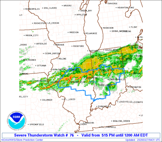
SUMMARY...Scattered severe thunderstorms are forecast to develop
into the evening with the stronger thunderstorms being capable of a
risk for large to very large hail and severe gusts. A tornado is
also possible, mainly over portions of eastern and northern Indiana.
This activity should gradually shift east-southeast during the
evening with the risk for severe wind gusts eventually becoming the
primary hazard.
The severe thunderstorm watch area is approximately along and 70
statute miles north and south of a line from 30 miles southwest of
Burlington IA to 30 miles southeast of Fort Wayne IN. For a complete
depiction of the watch see the associated watch outline update
(WOUS64 KWNS WOU6).
PRECAUTIONARY/PREPAREDNESS ACTIONS...
REMEMBER...A Severe Thunderstorm Watch means conditions are
favorable for severe thunderstorms in and close to the watch area.
Persons in these areas should be on the lookout for threatening
weather conditions and listen for later statements and possible
warnings. Severe thunderstorms can and occasionally do produce
tornadoes.
&&
OTHER WATCH INFORMATION...CONTINUE...WW 75...
AVIATION...A few severe thunderstorms with hail surface and aloft to
2.5 inches. Extreme turbulence and surface wind gusts to 70 knots. A
few cumulonimbi with maximum tops to 450. Mean storm motion vector
28040.
...Smith
   SEL6

   URGENT - IMMEDIATE BROADCAST REQUESTED
   Severe Thunderstorm Watch Number 76
   NWS Storm Prediction Center Norman OK
   515 PM EDT Thu Mar 26 2026

   The NWS Storm Prediction Center has issued a

   * Severe Thunderstorm Watch for portions of
     Far Southeast Iowa
     Central and Northern Illinois
     Central and Northern Indiana

   * Effective this Thursday afternoon from 515 PM until Midnight
     EDT.

   * Primary threats include...
     Scattered damaging winds and isolated significant gusts to 80
       mph likely
     Scattered large hail and isolated very large hail events to 2.5
       inches in diameter likely
     A tornado or two possible

   SUMMARY...Scattered severe thunderstorms are forecast to develop
   into the evening with the stronger thunderstorms being capable of a
   risk for large to very large hail and severe gusts.  A tornado is
   also possible, mainly over portions of eastern and northern Indiana.
   This activity should gradually shift east-southeast during the
   evening with the risk for severe wind gusts eventually becoming the
   primary hazard.

   The severe thunderstorm watch area is approximately along and 70
   statute miles north and south of a line from 30 miles southwest of
   Burlington IA to 30 miles southeast of Fort Wayne IN. For a complete
   depiction of the watch see the associated watch outline update
   (WOUS64 KWNS WOU6).

   PRECAUTIONARY/PREPAREDNESS ACTIONS...

   REMEMBER...A Severe Thunderstorm Watch means conditions are
   favorable for severe thunderstorms in and close to the watch area.
   Persons in these areas should be on the lookout for threatening
   weather conditions and listen for later statements and possible
   warnings. Severe thunderstorms can and occasionally do produce
   tornadoes.

   &&

   OTHER WATCH INFORMATION...CONTINUE...WW 75...

   AVIATION...A few severe thunderstorms with hail surface and aloft to
   2.5 inches. Extreme turbulence and surface wind gusts to 70 knots. A
   few cumulonimbi with maximum tops to 450. Mean storm motion vector
   28040.

   ...Smith
Note:
The Aviation Watch (SAW) product is an approximation to the watch area.
The actual watch is depicted by the shaded areas.
   SAW6
   WW 76 SEVERE TSTM IA IL IN 262115Z - 270400Z
   AXIS..70 STATUTE MILES NORTH AND SOUTH OF LINE..
   30SW BRL/BURLINGTON IA/ - 30SE FWA/FORT WAYNE IN/
   ..AVIATION COORDS.. 60NM N/S /39NNW UIN - 26SE FWA/
   HAIL SURFACE AND ALOFT..2.5 INCHES. WIND GUSTS..70 KNOTS.
   MAX TOPS TO 450. MEAN STORM MOTION VECTOR 28040.

   LAT...LON 41499153 41698478 39668478 39469153

   THIS IS AN APPROXIMATION TO THE WATCH AREA.  FOR A
   COMPLETE DEPICTION OF THE WATCH SEE WOUS64 KWNS
   FOR WOU6.
Watch 76 Status Report Messages:
STATUS REPORT #3 ON WW 76

VALID 270245Z - 270340Z

SEVERE WEATHER THREAT CONTINUES RIGHT OF A LINE FROM 35 W BRL TO
10 NE BRL TO 35 NW PIA TO 10 NNW BMI TO 20 NNW DNV TO 15 NW MIE
TO 40 SE FWA.

..CHALMERS..03/27/26

ATTN...WFO...DVN...LSX...ILX...LOT...IWX...IND...

&&

STATUS REPORT FOR WS 76

SEVERE WEATHER THREAT CONTINUES FOR THE FOLLOWING AREAS

ILC001-009-017-019-021-023-029-033-035-039-041-045-057-067-071-
079-095-101-107-109-113-115-125-129-137-139-143-147-149-167-169-
171-173-179-183-187-270340-

IL
.    ILLINOIS COUNTIES INCLUDED ARE

ADAMS     BROWN CASS
CHAMPAIGN     CHRISTIAN CLARK
COLES     CRAWFORD CUMBERLAND
DE WITT      DOUGLAS EDGAR
FULTON     HANCOCK HENDERSON
JASPER     KNOX LAWRENCE
LOGAN     MCDONOUGH MCLEAN
MACON     MASON MENARD
MORGAN     MOULTRIE PEORIA
PIATT     PIKE SANGAMON
SCHUYLER     SCOTT SHELBY
TAZEWELL     VERMILION WARREN
$$


INC011-021-023-027-035-045-055-057-059-063-065-075-081-083-093-
095-097-101-105-107-109-119-121-133-135-139-145-153-157-159-165-
167-171-270340-

IN
.    INDIANA COUNTIES INCLUDED ARE

BOONE     CLAY CLINTON
DAVIESS      DELAWARE FOUNTAIN
GREENE     HAMILTON HANCOCK
HENDRICKS     HENRY JAY
JOHNSON      KNOX LAWRENCE
MADISON      MARION MARTIN
MONROE     MONTGOMERY  MORGAN
OWEN     PARKE PUTNAM
RANDOLPH     RUSH SHELBY
SULLIVAN     TIPPECANOE  TIPTON
VERMILLION     VIGO WARREN
$$


IAC111-270340-

IA
.    IOWA COUNTIES INCLUDED ARE

LEE
$$


THE WATCH STATUS MESSAGE IS FOR GUIDANCE PURPOSES ONLY.  PLEASE
REFER TO WATCH COUNTY NOTIFICATION STATEMENTS FOR OFFICIAL
INFORMATION ON COUNTIES...INDEPENDENT CITIES AND MARINE ZONES
CLEARED FROM SEVERE THUNDERSTORM AND TORNADO WATCHES.
$$

STATUS REPORT #2 ON WW 76

VALID 270140Z - 270240Z

SEVERE WEATHER THREAT CONTINUES RIGHT OF A LINE FROM 25 NW MLI TO
30 NNW PIA TO 20 NW BMI TO 30 NW DNV TO 35 SE FWA.

..CHALMERS..03/27/26

ATTN...WFO...DVN...LSX...ILX...LOT...IWX...IND...

&&

STATUS REPORT FOR WS 76

SEVERE WEATHER THREAT CONTINUES FOR THE FOLLOWING AREAS

ILC001-009-017-019-021-029-039-041-045-057-067-071-095-107-109-
113-115-125-129-131-137-139-143-147-149-167-169-171-173-179-183-
187-270240-

IL
.    ILLINOIS COUNTIES INCLUDED ARE

ADAMS     BROWN CASS
CHAMPAIGN     CHRISTIAN COLES
DE WITT      DOUGLAS EDGAR
FULTON     HANCOCK HENDERSON
KNOX     LOGAN MCDONOUGH
MCLEAN     MACON MASON
MENARD     MERCER MORGAN
MOULTRIE     PEORIA PIATT
PIKE     SANGAMON SCHUYLER
SCOTT     SHELBY TAZEWELL
VERMILION     WARREN
$$


INC009-011-021-023-035-045-053-057-059-063-065-067-075-081-095-
097-107-109-119-121-133-135-139-145-157-159-165-167-171-
270240-

IN
.    INDIANA COUNTIES INCLUDED ARE

BLACKFORD     BOONE CLAY
CLINTON      DELAWARE FOUNTAIN
GRANT     HAMILTON HANCOCK
HENDRICKS     HENRY HOWARD
JAY     JOHNSON MADISON
MARION     MONTGOMERY  MORGAN
OWEN     PARKE PUTNAM
RANDOLPH     RUSH SHELBY
TIPPECANOE     TIPTON VERMILLION
VIGO     WARREN
$$


IAC057-087-111-270240-

IA
.    IOWA COUNTIES INCLUDED ARE

DES MOINES     HENRY LEE
$$


THE WATCH STATUS MESSAGE IS FOR GUIDANCE PURPOSES ONLY.  PLEASE
REFER TO WATCH COUNTY NOTIFICATION STATEMENTS FOR OFFICIAL
INFORMATION ON COUNTIES...INDEPENDENT CITIES AND MARINE ZONES
CLEARED FROM SEVERE THUNDERSTORM AND TORNADO WATCHES.
$$

STATUS REPORT #1 ON WW 76

VALID 262245Z - 262340Z

THE SEVERE WEATHER THREAT CONTINUES ACROSS THE ENTIRE WATCH AREA.

..BUNTING..03/26/26

ATTN...WFO...DVN...LSX...ILX...LOT...IWX...IND...

&&

STATUS REPORT FOR WS 76

SEVERE WEATHER THREAT CONTINUES FOR THE FOLLOWING AREAS

ILC001-009-011-017-019-021-029-039-041-045-053-057-063-067-071-
073-075-091-095-099-105-107-109-113-115-123-125-129-131-137-139-
143-147-149-155-167-169-171-173-175-179-183-187-197-203-
262340-

IL
.    ILLINOIS COUNTIES INCLUDED ARE

ADAMS     BROWN BUREAU
CASS     CHAMPAIGN CHRISTIAN
COLES     DE WITT DOUGLAS
EDGAR     FORD FULTON
GRUNDY     HANCOCK HENDERSON
HENRY     IROQUOIS KANKAKEE
KNOX     LA SALLE LIVINGSTON
LOGAN     MCDONOUGH MCLEAN
MACON     MARSHALL MASON
MENARD     MERCER MORGAN
MOULTRIE     PEORIA PIATT
PIKE     PUTNAM SANGAMON
SCHUYLER     SCOTT SHELBY
STARK     TAZEWELL VERMILION
WARREN     WILL WOODFORD
$$


INC001-003-007-009-011-015-017-023-033-035-039-045-049-053-057-
059-063-065-067-069-073-075-085-087-089-091-095-097-099-103-107-
111-113-121-127-131-133-135-141-149-151-157-159-165-169-171-179-
181-183-262340-

IN
.    INDIANA COUNTIES INCLUDED ARE

ADAMS     ALLEN BENTON
BLACKFORD     BOONE CARROLL
CASS     CLINTON DE KALB
DELAWARE     ELKHART FOUNTAIN
FULTON     GRANT HAMILTON
HANCOCK      HENDRICKS HENRY
HOWARD     HUNTINGTON  JASPER
JAY     KOSCIUSKO LAGRANGE
LAKE     LA PORTE MADISON
MARION     MARSHALL MIAMI
MONTGOMERY     NEWTON NOBLE
PARKE     PORTER PULASKI
PUTNAM     RANDOLPH ST. JOSEPH
STARKE     STEUBEN TIPPECANOE
TIPTON     VERMILLION  WABASH
WARREN     WELLS WHITE
WHITLEY
$$


IAC057-087-111-262340-

IA
.    IOWA COUNTIES INCLUDED ARE

DES MOINES     HENRY LEE
$$


THE WATCH STATUS MESSAGE IS FOR GUIDANCE PURPOSES ONLY.  PLEASE
REFER TO WATCH COUNTY NOTIFICATION STATEMENTS FOR OFFICIAL
INFORMATION ON COUNTIES...INDEPENDENT CITIES AND MARINE ZONES
CLEARED FROM SEVERE THUNDERSTORM AND TORNADO WATCHES.
$$
Note:
Click for Complete Product Text.
Tornadoes
| Probability of 2 or more tornadoes | Low (20%) |
| Probability of 1 or more strong (EF2-EF5) tornadoes | Low (10%) |
Wind
| Probability of 10 or more severe wind events | Mod (60%) |
| Probability of 1 or more wind events > 65 knots | Mod (60%) |
Hail
| Probability of 10 or more severe hail events | Mod (60%) |
| Probability of 1 or more hailstones > 2 inches | Mod (60%) |
Combined Severe Hail/Wind
| Probability of 6 or more combined severe hail/wind events | High (>95%) |
For each watch, probabilities for particular events inside the watch
(listed above in each table) are determined by the issuing forecaster.
The “Low” category contains probability values ranging from less than 2%
to 20% (EF2-EF5 tornadoes), less than 5% to 20% (all other probabilities),
“Moderate” from 30% to 60%, and “High” from 70% to greater than 95%.
High values are bolded and lighter in color to provide awareness of
an increased threat for a particular event.
Source link


