|
|
| Mesoscale Discussion 365 | |
 | |
Mesoscale Discussion 0365
NWS Storm Prediction Center Norman OK
1236 AM CDT Tue Apr 07 2026
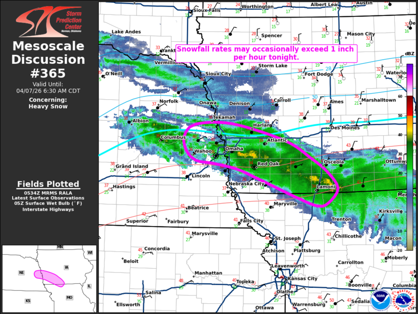
Areas affected...portions of eastern Nebraska into southwestern Iowa
and extreme northern Missouri
Concerning...Heavy snow
Valid 070536Z - 071130Z
SUMMARY...Snowfall rates may occasionally exceed 1 inch per hour
tonight from far eastern Nebraska into portions of southwestern Iowa
and extreme northern Missouri in association with a heavier band of
precipitation.
DISCUSSION...Latest radar imagery depicts an ongoing precipitation
band extending from portions of eastern Nebraska into northeastern
Missouri within a corridor of strong 700-600 mb frontogenesis. While
surface temperatures remain just above freezing in the mid-30s F,
continued low-level evaporative cooling amid weak cold, dry air
advection will support decreasing surface temperatures and a
transition from rain to snow as the primary precipitation type over
the next few hours. The aforementioned frontogenetic forcing and
favorable jet streak dynamics aloft are expected to contribute to
strong ascent within the dendritic growth zone, which may promote
occasional snowfall rates of 1 inch or more per hour within the
heaviest portions of the band.
Some uncertainty does remain regarding the degree of low-level
cooling, however, with some guidance suggesting that temperatures
within a low-level warm layer (evident around 850 mb in the 00Z OAX
sounding) may remain just above freezing. Should this occur, a
snow/sleet mix would be more likely.
..Chalmers.. 04/07/2026
...Please see www.spc.noaa.gov for graphic product...
ATTN...WFO...DMX...EAX...OAX...
LAT...LON 40369388 40509435 40839522 40979566 41069616 41129656
41289677 41539682 41719657 41729575 41449459 41149400
40939366 40659343 40409364 40369388
| |
| Top/All Mesoscale Discussions/Forecast Products/Home | |