|
|
| Mesoscale Discussion 346 | |
| Next MD > | |
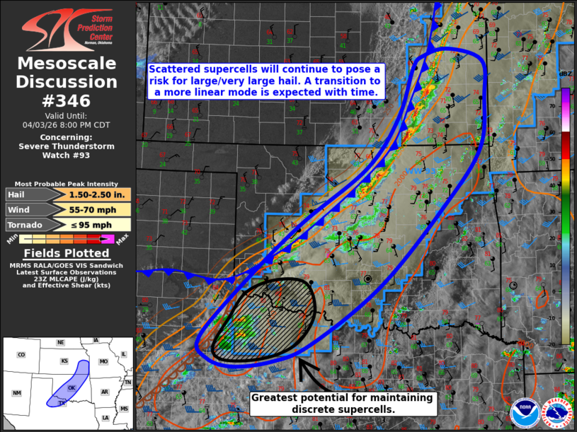 | |
Mesoscale Discussion 0346 NWS Storm Prediction Center Norman OK 0605 PM CDT Fri Apr 03 2026 Areas affected...portions of the Texas Rolling Plains into central Oklahoma and southeast Kansas Concerning...Severe Thunderstorm Watch 93... Valid 032305Z - 040100Z The severe weather threat for Severe Thunderstorm Watch 93 continues. SUMMARY...Scattered supercells continue to pose a threat for large/very large hail and damaging wind gusts. A transition to a more linear storm mode and severe wind threat is expected with time. The tornado threat remains conditional on a discrete storm persisting into the evening. DISCUSSION...Latest visible satellite/radar imagery depicts scattered supercells along a cold front/trailing dryline from eastern Kansas southwestward into the Texas Rolling Plains. While storms have struggled to maintain intensity thus far owing to lingering capping, moderate buoyancy (2000-2500+ J/kg MLCAPE) and 40-50 kts of effective bulk shear will continue to support discrete/semi-discrete supercells capable of large/very large hail to 2+ inches in diameter and severe wind gusts. Deep-layer shear vectors are largely oriented parallel to the southeastward progressing cold front, which is expected to favor upscale growth into a more linear storm mode over the next few hours, with a transition to severe wind gusts as the primary hazard. The tornado threat remains conditional on maintaining a discrete storm into the evening hours when a strengthening nocturnal low-level jet will favor increasing low-level shear/hodograph curvature. The greatest potential for discrete storm maintenance appears to be across northwest Texas into southwest Oklahoma in close proximity to a weak surface low located near the cold front/dryline intersection/ ..Chalmers.. 04/03/2026 ...Please see www.spc.noaa.gov for graphic product... ATTN...WFO...SGF...EAX...TSA...TOP...ICT...FWD...OUN...SJT... LUB... LAT...LON 33300053 33660068 34729968 35669858 36619722 37469655 38339622 38539602 38669547 38449472 37839468 36929480 35949559 34569695 33579838 33269917 33169999 33300053 MOST PROBABLE PEAK TORNADO INTENSITY...UP TO 95 MPH MOST PROBABLE PEAK WIND GUST...55-70 MPH MOST PROBABLE PEAK HAIL SIZE...1.50-2.50 IN | |
| Top/All Mesoscale Discussions/Forecast Products/Home | |