|
|
| Mesoscale Discussion 341 | |
| Next MD > | |
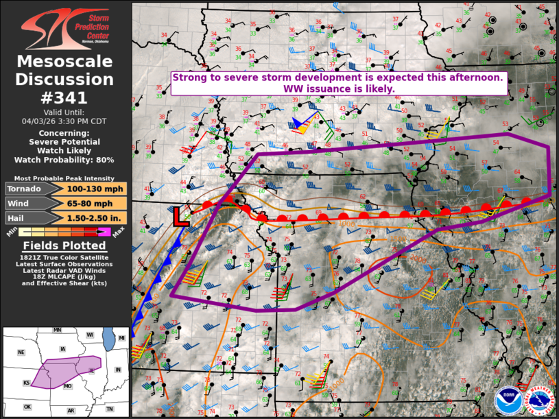 | |
   Mesoscale Discussion 0341
   NWS Storm Prediction Center Norman OK
   0126 PM CDT Fri Apr 03 2026

   Areas affected...Parts of central/eastern KS...western/northern
   MO...extreme southeast NE...southern IA...western IL

   Concerning...Severe potential...Watch likely

   Valid 031826Z - 032030Z

   Probability of Watch Issuance...80 percent

   SUMMARY...Strong to severe storm development is expected this
   afternoon. Watch issuance is likely.

   DISCUSSION...Isolated storm development is underway early this
   afternoon in the vicinity of a cold front across
   east-central/northeast KS. With mid 60s F dewpoints and temperatures
   rising through the 70s F, MLCINH has largely been removed along/east
   of the cold front and along/south of a northward-moving warm front
   draped from northeast KS into northern MO and west-central IL. Storm
   coverage is expected to increase through the afternoon, as a
   vigorous mid/upper-level shortwave trough moves across the Great
   Plains.

   Moderate to strong buoyancy (MLCAPE of 1500-2500 J/kg) and effective
   shear of 40-50 kt will support organized convection. Storm
   development near the cold front may initially evolve into
   supercells, with an attendant tornado and large hail threat. An
   eventual tendency toward a cluster or linear mode (accompanied by
   increasing damaging-wind potential) may occur along the cold front,
   due to increasing storm coverage and interaction.

   A separate area of supercell potential may evolve along the warm
   front from northern MO into west-central IL. Any surface-based
   supercell that can persist near the warm-frontal zone could pose a
   tornado threat, in addition to large hail and localized
   damaging-wind potential.

   Issuance of one or more watches is likely this afternoon, in
   response to the threats described above.

   ..Dean/Hart.. 04/03/2026

   ...Please see www.spc.noaa.gov for graphic product...

   ATTN...WFO...LOT...ILX...LSX...DVN...SGF...DMX...EAX...OAX...
   TOP...ICT...

   LAT...LON   38929662 40039599 40339569 40929512 40989391 41169105
               41258920 40988825 40138827 39708988 39589092 38469332
               38159418 38129508 38349703 38929662

   MOST PROBABLE PEAK TORNADO INTENSITY...100-130 MPH
   MOST PROBABLE PEAK WIND GUST...65-80 MPH
   MOST PROBABLE PEAK HAIL SIZE...1.50-2.50 IN
| |
| Top/All Mesoscale Discussions/Forecast Products/Home | |