|
|
| Mesoscale Discussion 322 | |
| Next MD > | |
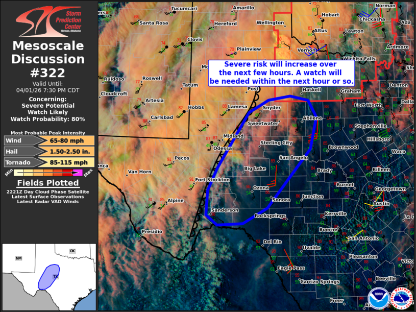 | |
   Mesoscale Discussion 0322
   NWS Storm Prediction Center Norman OK
   0525 PM CDT Wed Apr 01 2026

   Areas affected...Parts of southwest Texas

   Concerning...Severe potential...Watch likely

   Valid 012225Z - 020030Z

   Probability of Watch Issuance...80 percent

   SUMMARY...The risk of severe storms capable of producing large hail
   and severe wind gusts will increase over the next few hours. A watch
   will be needed within the next hour or so.

   DISCUSSION...The latest visible satellite and radar data show a
   gradual increase in high-based convection developing on the
   immediate hot/dry side of the dryline extending across southwest TX.
   While it is unclear if these early storms will pose a substantial
   severe risk in the near term, a deeply mixed boundary layer and
   around 40 kt of midlevel west-southwesterly flow orthogonal to the
   dryline could promote a couple severe downburts and sporadic large
   hail with any storms that mature. With time, additional storm
   development is expected as modest large-scale ascent influences the
   area and enhances surface convergence along the dryline.
   Elongating/mostly straight hodographs (effective shear increasing to
   around 50 kt) and steep deep-layer lapse rates/moderate
   surface-based buoyancy should support a mix of semi-discrete
   supercells and clusters with a risk of large to very large hail and
   severe wind gusts. With time, these storms should grow upscale and
   pose a continued/increasing risk of scattered severe winds. While
   less likely, a tornado or two will also be possible as storms
   intercept a strengthening nocturnal low-level jet this
   evening/overnight. A watch will likely be needed within the next
   hour or so.

   ..Weinman/Leitman.. 04/01/2026

   ...Please see www.spc.noaa.gov for graphic product...

   ATTN...WFO...EWX...SJT...LUB...MAF...

   LAT...LON   30710247 31280220 32680128 32980071 33090007 32979954
               32569930 31759948 30290075 29890145 29850220 30110252
               30710247

   MOST PROBABLE PEAK TORNADO INTENSITY...85-115 MPH
   MOST PROBABLE PEAK WIND GUST...65-80 MPH
   MOST PROBABLE PEAK HAIL SIZE...1.50-2.50 IN
| |
| Top/All Mesoscale Discussions/Forecast Products/Home | |