|
|
| Mesoscale Discussion 316 | |
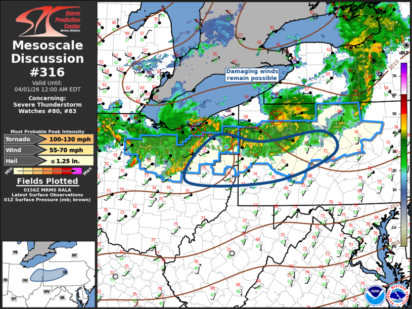 | |
Mesoscale Discussion 0316 NWS Storm Prediction Center Norman OK 0858 PM CDT Tue Mar 31 2026 Areas affected...Upper Ohio Valley Concerning...Severe Thunderstorm Watch 80...83... Valid 010158Z - 010400Z The severe weather threat for Severe Thunderstorm Watch 80, 83 continues. SUMMARY...Locally damaging winds will accompany squall line this evening. DISCUSSION...Surface front is gradually advancing southeast across the Great Lakes this evening as a midlevel short-wave trough shifts across LE/northern OH. An elongated, complex MCS has evolved ahead of this feature with several clusters propagating east-southeast across western PA into northern OH. In both cases a weak MCV is likely evident within the broader precip shield which is indicative of the maturity of this convection. Latest radar data suggests damaging winds may be noted along the leading edge of these arc-shaped squall lines. Although buoyancy is gradually decreasing across this region, at least for the next few hours robust convection will likely continue. ..Darrow.. 04/01/2026 ...Please see www.spc.noaa.gov for graphic product... ATTN...WFO...CTP...PBZ...CLE... LAT...LON 40258203 40257948 40877768 41377801 41167980 41278121 40258203 MOST PROBABLE PEAK TORNADO INTENSITY...100-130 MPH MOST PROBABLE PEAK WIND GUST...55-70 MPH MOST PROBABLE PEAK HAIL SIZE...UP TO 1.25 IN | |
| Top/All Mesoscale Discussions/Forecast Products/Home | |
