|
|
| Mesoscale Discussion 305 | |
| Next MD > | |
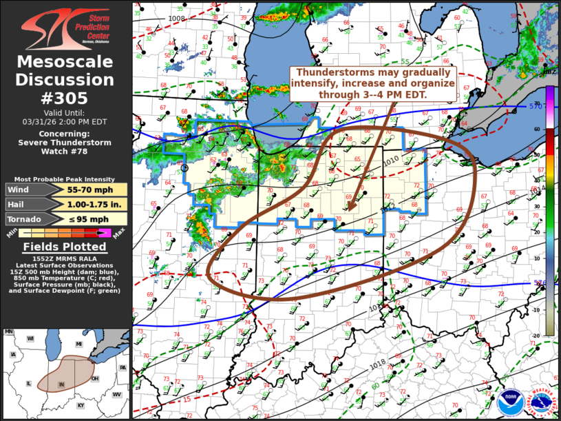 | |
Mesoscale Discussion 0305 NWS Storm Prediction Center Norman OK 1055 AM CDT Tue Mar 31 2026 Areas affected...parts of southern Lower Michigan...east central Illinois...northern and central Indiana...northwestern Ohio Concerning...Severe Thunderstorm Watch 78... Valid 311555Z - 311800Z The severe weather threat for Severe Thunderstorm Watch 78 continues. SUMMARY...Thunderstorms may gradually begin to intensify and consolidate into an organizing cluster with increasing risk for producing potentially damaging wind gusts through 3-4 PM EDT. Additional severe weather watches may be needed and trends are being monitored for this possibility. DISCUSSION...Forcing for ascent downstream of a low amplitude short wave trough, along the southern fringe of the stronger westerlies, has been supporting an ongoing area of convective development overspreading northern/central Illinois and adjacent portions of the Midwest. This has included stronger embedded thunderstorms which have been producing small to occasionally marginal severe hail. As this develops eastward, insolation downstream is contributing to boundary-layer destabilization of a modestly moist boundary characterized by mid 50s+ F surface dew points, but with a tongue of near 60F+ dew points emanating from the lower Mississippi Valley now advecting across and northeast of southeastern Illinois and southern central Indiana. As this develops toward the lower Great Lakes vicinity through 19-20Z, upstream thunderstorm activity may gradually begin to intensify, grow upscale and organize in the presence of modestly sheared 30-40 kt westerly deep-layer mean flow. This may slowly be accompanied by increasing potential to produce strong to severe surface gusts, in addition to occasional severe hail. ..Kerr.. 03/31/2026 ...Please see www.spc.noaa.gov for graphic product... ATTN...WFO...CLE...ILN...DTX...IWX...IND...LOT...ILX... LAT...LON 41878347 41298279 40088354 39258667 39548851 40408788 41078654 42028576 41878347 MOST PROBABLE PEAK TORNADO INTENSITY...UP TO 95 MPH MOST PROBABLE PEAK WIND GUST...55-70 MPH MOST PROBABLE PEAK HAIL SIZE...1.00-1.75 IN | |
| Top/All Mesoscale Discussions/Forecast Products/Home | |

