|
|
| Mesoscale Discussion 299 | |
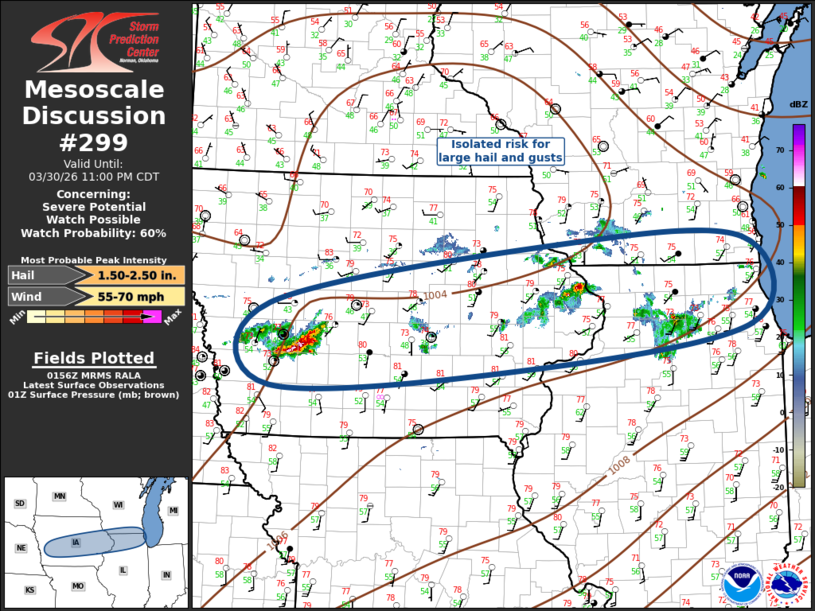 | |
   Mesoscale Discussion 0299
   NWS Storm Prediction Center Norman OK
   0857 PM CDT Mon Mar 30 2026

   Areas affected...Portions of the Midwest

   Concerning...Severe potential...Watch possible

   Valid 310157Z - 310400Z

   Probability of Watch Issuance...60 percent

   SUMMARY...Risk for isolated large hail, and perhaps gusty winds with
   thunderstorms tonight.

   DISCUSSION...Water-vapor imagery suggests a weak low-amplitude
   short-wave trough is ejecting across eastern SD/NE. Strong heating
   this afternoon allowed the boundary layer to warm significantly and
   this led to steep 0-3km lapse rates south of the front from eastern
   NE into eastern IA. 00z sounding from OAX supported this with near
   dry adiabatic lapse rates through 3km. As a result, isolated
   high-based thunderstorms developed earlier this evening but have
   struggled somewhat until the last hour or so. It appears a
   decoupling boundary layer and strengthening LLJ may be partly
   responsible for more robust updrafts from Cass into Guthrie County
   IA. Current thinking is elevated convection may gradually increase
   in areal coverage along an east-west corridor from central IA toward
   southern Lake MI. Forecast soundings suggest parcels will likely be
   lifted near 850mb and this will be supported by both the veered but
   strengthening LLJ, and the weak upstream short wave. Hail is the
   primary concern with this activity.

   ..Darrow/Guyer.. 03/31/2026

   ...Please see www.spc.noaa.gov for graphic product...

   ATTN...WFO...LOT...MKX...DVN...ARX...DMX...OAX...

   LAT...LON   42049513 42739084 42788805 41818795 41329149 41149513
               42049513

   MOST PROBABLE PEAK WIND GUST...55-70 MPH
   MOST PROBABLE PEAK HAIL SIZE...1.50-2.50 IN
| |
| Top/All Mesoscale Discussions/Forecast Products/Home | |