|
|
| Mesoscale Discussion 261 | |
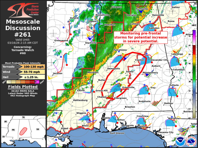 | |
Mesoscale Discussion 0261 NWS Storm Prediction Center Norman OK 0121 AM CDT Mon Mar 16 2026 Areas affected...Parts of southwest and central Alabama Concerning...Tornado Watch 60... Valid 160621Z - 160715Z The severe weather threat for Tornado Watch 60 continues. SUMMARY...A couple storms evolving ahead of the main squall line are being monitored for a potential increase in severe potential. DISCUSSION...Ahead of a squall line advancing eastward across western AL, a couple storms are evolving within a plume of weak low-level warm advection and surface confluence. While lingering inhibition (sampled by 04Z BMX sounding) and weak forcing for ascent cast uncertainty on intensification of these storms -- especially before being overtaken by the approaching QLCS -- large clockwise-curved hodographs (around 200-300 m2/s2 effective SRH) and ample buoyancy will conditionally favor intensification into a supercell or two. If this were to occur, all severe hazards would be possible, including tornadoes. ..Weinman.. 03/16/2026 ...Please see www.spc.noaa.gov for graphic product... ATTN...WFO...BMX...MOB... LAT...LON 31788805 32298778 33078701 33188670 33138636 32958611 32758614 32478633 31688712 31458751 31528799 31788805 MOST PROBABLE PEAK TORNADO INTENSITY...100-130 MPH MOST PROBABLE PEAK WIND GUST...55-70 MPH MOST PROBABLE PEAK HAIL SIZE...UP TO 1.25 IN | |
| Top/All Mesoscale Discussions/Forecast Products/Home | |