| Mesoscale Discussion 14 | |
| < Previous MD | |
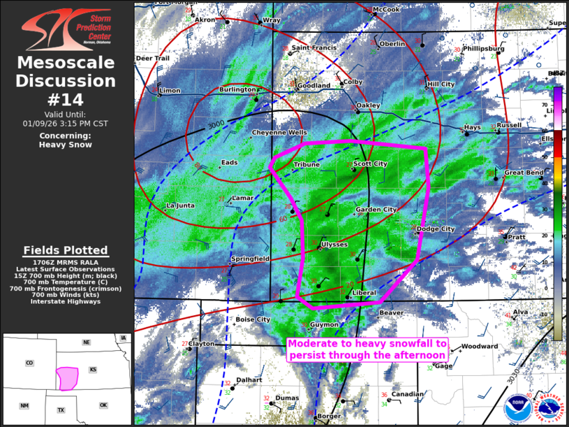 | |
   Mesoscale Discussion 0014
   NWS Storm Prediction Center Norman OK
   1108 AM CST Fri Jan 09 2026

   Areas affected...Southwestern Kansas

   Concerning...Heavy snow

   Valid 091708Z - 092115Z

   SUMMARY...Snowfall rates exceeding 1.0 inches/hour expected to
   persist across southwestern Kansas through the afternoon.

   DISCUSSION...Moderate to heavy snowfall exceeding 1.0 inches/hour is
   currently occurring across portions of western/southwestern Kansas
   in the presence of surface cold air advection and 700mb
   frontogenesis. The expectation is for these moderate to heavy
   snowfall rates to persist at least through 20Z this afternoon, when
   HREF mean snowfall rates diminish substantially. Surface winds
   between 10-20 MPH may result in intermittent periods of reduced
   visibility.

   ..Halbert.. 01/09/2026

   ...Please see www.spc.noaa.gov for graphic product...

   ATTN...WFO...DDC...GLD...AMA...PUB...

   LAT...LON   38600200 38750156 38790091 38699985 38269981 37469999
               36980050 36910144 37050167 37470158 37890160 38150177
               38480206 38600200
| |
| Top/All Mesoscale Discussions/Forecast Products/Home | |
Related posts
S.254
October 8, 2025
Judge Halts Trump’s Anti-Voting Executive Order
April 24, 2025